Peninsular Drainage System
- Peninsular rivers are much older than Himalayan Rivers.
- The peninsular drainage is mainly concordant except for a few rivers in Upper Peninsula region.
- They are non-perennial rivers with maximum discharge in rainy season.
- Peninsular rivers have reached mature stage and have almost reached their base level hence, vertical down cutting is negligible.
- Rivers are characterized by broad and shallow valley.
- River banks shows gentle slope except for limited taxpayer flaunting forms Street sides.
- The main water divide in Peninsular River is by Western Ghats which runs from north to south close to Western coast.
- Velocity of water in peninsular rivers and the load carrying capacity of streams is low due to low gradient.
- Peninsular drainage system can be divided into following parts –
-
- East Flowing Peninsular Rivers like Mahanadi, Godavari, Krishna, Kaveri. These rivers form delta at their mouth.
- West Flowing Peninsular Rivers of Narmada and Tapi which drains into Arabian Sea. These river form estuaries.
Evolution of Peninsular River System
Three major geological events in the distant past have shaped the present drainage systems of Peninsular India –
-
- Geologists believe that the Sahyadri-Aravalli axis was the main water divide in the past.
- Based on one hypothesis, the existing peninsula is the remaining half of bigger landmass.
- The Western Ghats were located in the middle of this landmass. Which divides the drainage into two half’s.
- So one drainage was towards east flowing into Bay of Bengal and the other towards west draining into Arabian Sea.
- The western part of the Peninsula cracked and submerged in the Arabian Sea during the early Tertiary period.
- During the collision of the Indian plate, the peninsular block was subjected to subsidence creating rift valleys or faults.
- The now west flowing rivers of the Peninsula, namely the Narmada and the Tapi flow through these rifts.
- This theory is proved by the facts such as Straight coastline, steep western slope of the Western Ghats, and the absence of delta formations on the western coast.
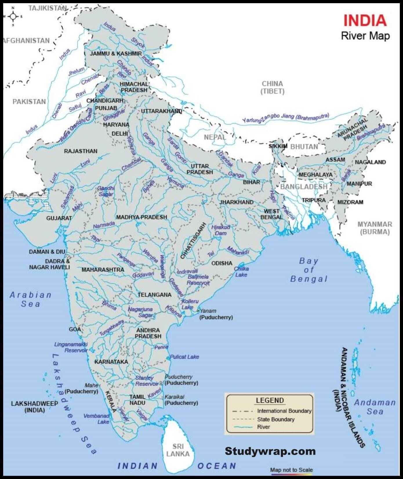
Peninsular River System
-
- Rivers that drain into Bay of Bengal
The Mahanadi, the Godavari, the Krishna, the Cauvery and several smaller rivers drains south-east into the Bay of Bengal.
-
- Rivers that drain into Arabian Sea
The Narmada, the Tapi, the Mahi flowing west as well as several small streams originating from the Western Ghats flow westwards into the Arabian Sea.
-
- Rivers that drain into the Ganga
Tributaries of the Ganga and the Yamuna such as the Chambal, the Betwa, the Ken, the Son and the Damodar flow in the north-easterly direction.
West Flowing Peninsular Rivers
-
- The west flowing rivers of the Peninsular India are fewer and smaller as compared to their east flowing rivers.
- The two major West Flowing Peninsular Rivers are the Narmada and the Tapi.
- The Sabarmati, Mahi and Luni are other rivers of the Peninsular India which flow westwards.
- Besides, these Hundreds of small streams originating in the Western Ghats flow swiftly westwards and join the Arabian Sea.
- This exceptional behaviour is because these rivers didn’t form valleys and instead they flow through faults (linear rift, rift valley, and trough) created due to the bending of the northern peninsula during the formation process of Himalayas.
- These faults run parallel to the Vindhyas and the Sapura’s.
- It is interesting to note that the Peninsular Rivers which fall into the Arabian Sea do not form deltas, but only estuaries.
- This is due to the fact that the west flowing rivers, especially the Narmada and the Tapi flow through hard rocks and hence do not carry any good amount of silt.
- Moreover, the tributaries of these rivers are very small and hence they don’t contribute any silt.
- Hence these rivers are not able to form distributaries or a delta before they enter the sea.
- Some of the Important West flowing Peninsular Rivers are –
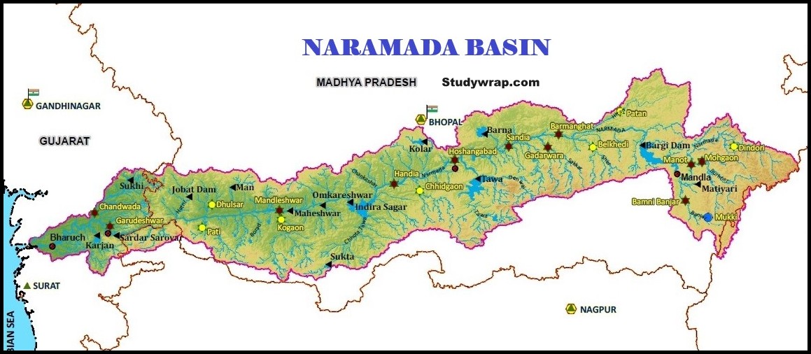
1. Narmada
|
Narmada Studywrap.com
|
|
Origin and River Course
|
Tributaries
|
- Rises from Maikal range near Amarkantak in Madhya Pradesh, at an elevation of about 1057 m.
- basin extends over states of Madhya Pradesh, Gujarat, Maharashtra and Chhattisgarh having an area of 98,796 Sq.km
- Largest West Flowing Peninsular Rivers of India.
- Total length – 1312 km
- It is bounded by the Vindhyas on the north, by the Maikal range on the east, by the Satpura on the south and by the Arabian Sea on the west.
- After flowing for about 400 km from its source, the river slopes down Jabalpur where it cascades 15 m into a gorge to form the Dhuan Dhar (cloud of mist) Waterfall. Since the gorge is composed of Marbles, it is popularly known as Marble Rocks.
- Below Jabalpur it flows it flows in a narrow elongated and well defined basin and forms a few rapids.
- It makes two waterfalls of 12 m each at Mandhar and Dardi. Near Maheshwar the river again descends from another small fall of 8 m, known as the Sahasradhara Falls.
- There are several islands in the estuary of the Narmada of which Aliabet is the largest.
- At the confluence to the Sea the mouth of the river is 28 km wide. Narmada drains into the Arabian Sea through the Gulf of Khambhat.
- River is navigable upto 112 km from its mouth.
|
- Since the river flows through a narrow valley confined by precipitous (dangerously high or steep) hills, it does not have many tributaries.
- The absence of tributaries is especially noted on the right bank of the river where the Hiran is the only exception.
- The other right bank tributaries are the Orsang, the Barna and the Kolar.
- A few left bank tributaries drain the northern slopes of the Satpura Range and join the Narmada at different places.
- Left Bank Tributaries – the Burhner, the Banjar, the Sher, the Shakkar, the Dudhi, the Tawa , the Ganjal, the Kundi, the Goi and the Karjan
- Right Bank Tributaries – the Hiran, the Tendoni, the Barna, the Kolar, the Man, the Uri, the Hatni and the Orsang.
|
|
Projects
|
Industries
|
Floods and Droughts
|
- The surface water development in the basin had been very insignificant during the pre-plan period. Tawa, Barna and Sukha are the important projects completed during the plan period.
- Among the projects under construction in the basin, Sardar Sarovar, Indira Sagar, Bargi and Omkareshwar are the most important. Recently Sardar Sarovar Dam has been completed.
- The major Hydro Power Project in the basin are Indira Sagar, Sardar Sarovar, Omkareshwar, and Bargi & Maheshwar.
|
- Jabalpur is the only important urban centre in the basin.
- Other important towns situated in the basin are Khandwa and Baruch.
- The basin has only few industries located mainly at Jabalpur, Khandwa and Baruch.
- These are textiles, drugs and pharmaceuticals, tobacco products, machine tools, glass and ceramics etc.
|
- The Narmada and Tapi Rivers in central India are characterized by one of the most intense flood regimes in the seasonal tropics.
- River is seasonal in nature i.e. it has more than abundant water in monsoon season as compared to others seasons. Hence this sometimes result in floods.
|
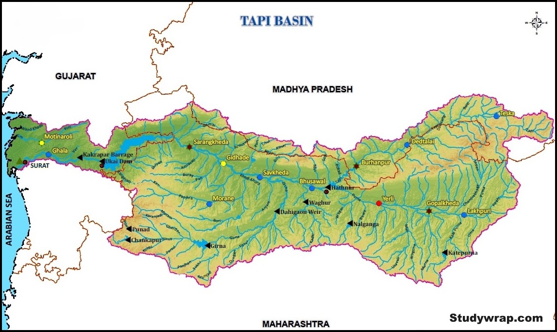
2. Tapi
|
Tapi Studywrap.com
|
|
Origin and River Course
|
Tributaries
|
- Originates near Multai reserve forest in Betul district of Madhya Pradesh at an elevation of 752 m.
- Total length – 724 km.
- Basin extends over states of Madhya Pradesh, Maharashtra and Gujarat having an area of 65,145 Sq.km.
- Situated in the Deccan plateau, the basin is bounded by the Satpura range on the north, by the Mahadeo hills on the east, by the Ajanta Range and the Satmala hills on the south and by the Arabian Sea on the west.
- The Tapi is the second largest West Flowing Peninsular Rivers of India.
- The basin lies in the State of Maharashtra and a small area in Madhya Pradesh and Gujarat.
- It rises in the eastern Satpura Range of southern Madhya Pradesh state, and flows westward, draining Madhya Pradesh’s Nimar region.
- It flows for 228 Km in Maharashtra draining Khandesh and east Vidarbha regions in the northwest corner of the Deccan Plateau before entering Gujarat.
- Traversing a length of 214 Km in Gujarat, the Tapi joins Arabian Sea in Gulf of Cambay after flowing past the Surat city.
- The river receives tidal influence for a length of about 20 Km upstream from mouth.
|
- Right Bank Tributaries – the Vaki, the Gomai, the Arunavati and the Aner
- Left Bank Tributaries – the Nesu, the Arunavati, the Buray, the Panjhra, the Bori, the Girna, the Vaghur, the Purna, the Mona and the Sipna.
- The Purna and the Girna, the two important left bank tributaries together account for nearly 45 percent of the total catchment area of the Tapi.
|
|
Projects
|
Industries
|
Floods and Droughts
|
- Some of the important projects are Hathnur Dam of Upper Tapi Project, Kakrapar weir and Ukai Dam of Ukai Project, Girna Dam and Dahigaon Weir of Girna Project.
- At present Hydro Power station is located in Ukai Dam.
|
- Important industries in the basin are textile factories in Surat and paper and news print factory at Nepanagar.
- Other industries are machine tools, drugs and pharmaceuticals, plastic and allied products.
|
- River is seasonal in nature i.e. it has more than abundant water in monsoon season as compared to others seasons. Hence this sometimes result in floods.
|
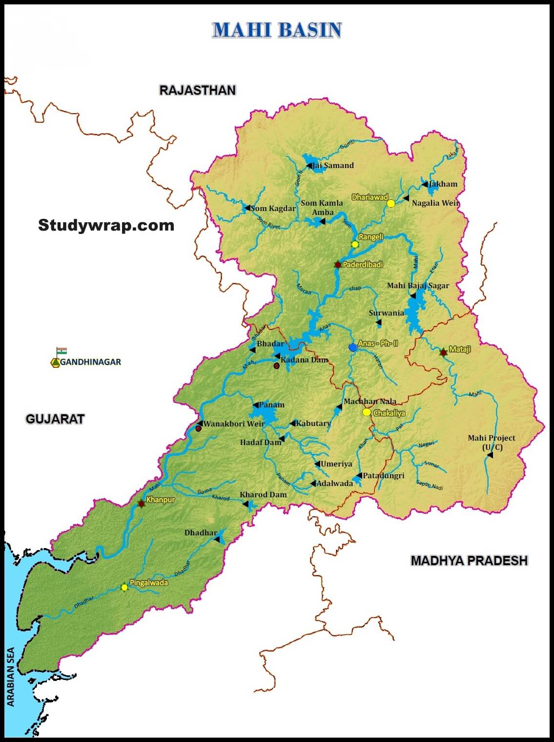
3. Mahi
|
Mahi Studywrap.com
|
|
Origin and River Course
|
- Originates from the northern slopes of Vindhyas at an altitude of 500 m in Dhar district of Madhya Pradesh.
- Total length – 583 km.
- Basin extends over states of Madhya Pradesh, Rajasthan and Gujarat having total area of 34,842 Sq.km.
- Bounded by Aravalli hills on the north and the north-west, by Malwa Plateau on the east, by the Vindhyas on the south and by the Gulf of Khambhat on the west.
- Initially the river flows Northwards through Dhar and Jhabua districts of Madhya Pradesh and then turns left and passes through the Ratlam district of Madhya Pradesh, then turning to North – West, it enters the Banswara district of Rajasthan and flows in South – West directions and thereafter enters the Panchmahal district of Gujarat state.
- Then the river continuously flows in the same direction through Kheda district of Gujarat and finally falls into the Gulf of Khambhat in Arabian Sea.
|
|
Tributaries
|
Industries
|
Projects
|
- The main tributaries are Som, Anas and Panam.
|
- Major part of basin is covered with agricultural land accounting to 63.63% of the total area.
- Vadodara is the only important urban centre in the basin.
- There are not many industries in the basin. Some of the industries are cotton textile, paper, newsprint, drugs and pharmaceuticals. Most of these industries are located at Tatlam.
|
- Jaisamund tank in Udaipur district of Rajasthan is the oldest irrigation project in the basin constructed in the pre-plan period.
- The important projects in the basin constructed during plan period are Mahi Bajaj Sagar, Jakham, Panam, Mahi Phase – I & II comprising of Wankbori weir and Kadana dam and Mahi (M.P.) projects.
- At present Hydro Power stations are located in Mahi Bajaj Sagar dam and at Kadana Dam. The Power house located at Kadana is a pump storage scheme.
|
4.Sabarmati
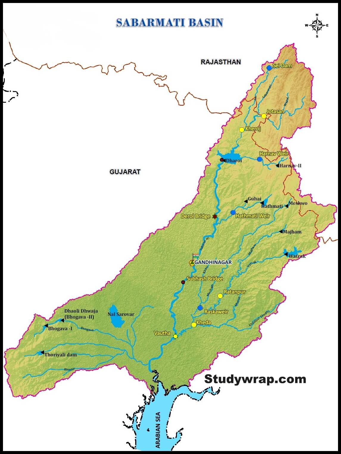
|
Sabarmati Studywrap.com
|
|
Origin and River Course
|
- Originates from Aravalli hills at an elevation of 762 m in Udaipur district of Rajasthan.
- Total length – 371 km
- Basin extends over states of Rajasthan and Gujarat having an area of 21,674 Sq.km
- Basin is bounded by Aravalli hills on the north and north-east, by Rann of Kutch on the west and by Gulf of Khambhat on the south.
- From its origin it flows generally in South – West direction.
- It enters the Gujarat State and passes through the plains and continues to flow in the same direction and joins the Gulf of Khambhat in the Arabian Sea.
|
|
Tributaries
|
Industries
|
Projects
|
- Left bank tributary – the Watrak, the Hathmati, the Harnav, the Wakal
- Right bank tributary – the Sei
|
- Major part of basin is covered with agriculture accounting to 74.68% of the total area.
- Gandhinagar and Ahmedabad are the important urban centres in the basin. Ahmedabad is an industrial city situated on the banks of Sabarmati.
- Important industries are textiles, leather and leather goods, plastic, rubber goods, paper, newsprint, automobile, machine tools, drugs and pharmaceuticals etc.
|
- Sabarmati basin is well-developed in water resources. Most of the project are medium and minor.
- Before plan period Meshwo canal and Kharicut canal system was developed.
- Sabarmati reservoir (Dharoi), Hathmati reservoir and Meshwo reservoir project are major projects completed during the plan period.
|
5. Luni
-
-
- Originates from western slopes of the Aravalli ranges at an elevation of 772 m above mean sea level near Ajmer, Rajasthan flowing in South West direction and traversing a course of 511 km in Rajasthan, it finally flow into the Rann of Kachchh.
- Total length – 581 km.
- The river is known as Sagarmati in its upper course.
- It is joined by the Sarsuti after passing Govindgarh and after this confluence it is known as Luni.
- It gets lost in the marshy grounds at the heads of Rann of Kachchh.
- Rivers has low Gradient and flows through wide plains without a well-marked valley.
- This river is that it tends to increase its width rather than deepening the bed because the banks are of soils, which are easily erodible whereas beds are of sand. The floods develop and disappear so rapidly that they have no time to scour the bed.
- Its total catchment area falls in Rajasthan. It is a small stream but has got a distinction of flowing through Thar Desert.
- The Luni or the Salt River (Lonari or Lavanavari in Sanskrit) is named so because its water is brackish below Balotra.
- Luni is the only river basin of any significance in Western Rajasthan, which form the bulk of arid zone.
6. West Flowing Rivers of Sahyadris
-
-
- About six hundred small streams originate from the Western Ghats and flow westwards to fall into the Arabian Sea.
- The western slopes of the Western Ghats receive heavy rainfall from the south-west monsoons and are able to feed such a large number of streams.
- It constitutes about 18% of the country’s water resources.
- Some of the important rivers in this categories are –
-
-
- Madovi, Zuari and Rachol in Goa
- Kalinadi, Saravati, Tadri and Netravati in Karnataka
- Periyar, Pamba, Pannam and Beypore in Kerala.
- Although only about 3% of the areal extent flow swiftly down the steep slope and some of them make waterfalls.
- The Jog or Gersoppa Falls (289 m) made by the Sharavati river is the most famous waterfall of India.
So, this was all about the West Flowing Peninsular Rivers of India.
In the next post (Click here), we would study in detail about East Flowing Peninsular Rivers.


Nice Detailed Notes … Thanks for Sharing … :-)