
Important Boundaries Lines in the World
Important Boundaries Lines in the World
Table of Contents
International Boundary Lines
- International boundaries serve as geographical borders between political and legal jurisdictions such as countries, customs territories, and sovereign states.
- International boundaries are the demarcations that separate two sovereign countries, defining their territories and legal jurisdictions. The process of creating these borders is known as boundary delimitation.
- For example, the Line of Control (LoC) is the boundary line between India (Kashmir) and Pakistan.
- The Mason-Dixon Line is a boundary line between the 4 states of the United States of America.
- Some international borders such as those within a free movement area like the European Union are thinly guarded or completely open.
- Others such as the India-Pakistan border or the North Korea-South Korea border may be heavily patrolled with access controlled through designated crossings.

Important International Borders
Following are the Important Boundaries Lines in the World between different countries –
|
Boundaries |
Between |
Description |
|
16th Parallel North |
Namibia & Angola |
The border line between Namibia & Angola. |
|
17th Parallel |
South Vietnam and North Vietnam |
The 17th latitude from the equator divided erstwhile North and South Vietnam. It was demarcated based on the 1954 Geneva Accords. |
|
20th Parallel |
Libya and Sudan |
It is located at the 20th northern latitude which is used as the border between Sudan and Libya. |
|
22nd Parallel |
Egypt and Sudan |
The 22nd latitude north of the equator marks a major portion of the Sudan-Egypt border. |
|
25th Parallel |
Mauritania and Mali |
The northernmost section of the Mali-Mauritania border is marked using this line. |
|
31st Parallel |
Iran and Iraq |
The 31st northern latitude marks the border between Iraq and Iran. It also demarcates the border between the US states of Louisiana and Mississippi. |
|
38th Parallel |
South Korea and North Korea |
Known as Military Demarcation Line. The Military Demarcation Line (MDL), sometimes referred to as the Armistice Line. The 38th parallel is used to demarcate the central part of the Demilitarized zone between North and South Korea. |
|
49th Parallel |
USA and Canada |
It is located 49 degrees north of the equator. Demarcated after the Anglo-American Convention of 1818 and the Oregon Treaty of 1846, it forms the international border between the northern USA (Excluding Alaska) and Canada. |
|
Durand Line |
Pakistan and Afghanistan |
Delimited by Sir Mortimer Durand with the agreement of the erstwhile Amir of Afghanistan in 1893. Present-day Afghanistan does not recognize the Durand line. |
|
Hindenburg Line |
Poland and Germany |
It was a German Defensive line in French territory during World War I. It was rendered irrelevant by the treaty of Versailles in 1919. |
|
McMahon Line |
China and India |
It was drawn by Sir Henry McMahon in consultation with Tibetan representatives in 1914. China disputes the legal status of this line but it is the de facto border between India and China. |
|
Maginot Line |
Germany and France |
It was a defensive line at the French border towards Germany before World War II. The Maginot line was rendered obsolete following the successful invasion of France by Germany following the outbreak of World War II. |
|
Mannerheim Line |
Russia and Finland |
Finland built this as a defensive line against the Soviet Union for the Winter War during World War II. |
|
Oder-Neisse Line |
Poland and Germany |
It runs along the rivers Oder and Lusatian Neisse rivers. |
|
Radcliffe Line |
India and Pakistan |
It was demarcated by Sir Cyril Radcliffe for the Partition of India and the formation of East and West Pakistan. It includes present-day India, Bangladesh, and Pakistan. |
|
Siegfried Line |
France and Germany |
It was built as an extension of the Hindenburg defensive line on the western front of World War I by the Weimar Republic and later the Third Reich of Germany in the 1930s. |
|
Blue Line |
Lebanon and Israel |
Border demarcation between Lebanon and Israel was published by the United Nations on 7 June 2000 for the purposes of determining whether Israel had fully withdrawn from Lebanon. |
|
Green Line / Attila Line / UN Buffer Zone |
The Republic of Cyprus and Turkish Cyprus |
A demilitarized zone, patrolled by the United Nations Peacekeeping Force in Cyprus (UNFICYP), that was established in 1964 and extended in 1974 after the ceasefire of 16 August 1974. |
|
Purple Line |
Israel and Syria |
The Purple Line was the ceasefire line between Israel and Syria after the 1967 War. |
India’s Border Line Name List
India shares its international borders with seven neighbouring countries, and two of the most significant boundary lines are the Radcliffe Line and the McMahon Line.
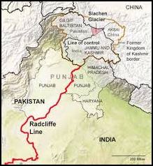
Radcliffe Line
The Radcliffe Line, is the international boundary line between Pakistan and India.
It runs from Gujarat to the Jammu and Kashmir (J&K) border.
It was created on August 17, 1947, and played a pivotal role in the partition of British India into three parts – India, West Pakistan, and East Pakistan (now present-day Bangladesh).
The borderline between India and Pakistan also passes through the Jammu and Kashmir region, where it is referred to as the Line of Control (LOC).
McMahon Line
The McMahon Line serves as the international boundary line between India and China, extending from the eastern border of Bhutan to the Himalayas until it reaches the great bend in the Brahmaputra River.
Named after Sir Henry McMahon, the former foreign secretary of British India, this boundary line was established through a bilateral agreement signed between Tibet and Britain at a conference in Shimla on July 3, 1914.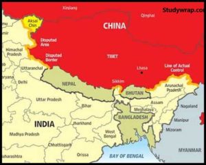
The McMahon Line stretches approximately 890 km in length, marking a significant border between India and China.
Line of Actual Control (LAC)
The Line of Actual Control (LAC) acts as the de facto borderline between India and China.
Initially, it began as a ceasefire line, but it later evolved into an informal boundary separating the territories of China and India.
The LAC is not a precisely defined boundary, leading to occasional disputes and tensions between the two neighbouring countries.
Important Facts about Important Boundaries Lines in the World
Highest International Boundary
The border between Nepal and China, running across the top point of Mount Everest at 8848 meters (29029 feet) above sea level.
Longest International Boundary
The 5525-mile-long border between Canada and the United States; the longest undefended border in the world.
Most Lit-up International Boundary Line
The Radcliffe Line, bordering India and Pakistan, as captured in a NASA snapshot from the International Space Station.
Most Guarded International Boundary Line
The Korean Demilitarized Zone (DMZ) between South and North Korea, approximately 250 km long and 4 km wide.
So, this is all about the Important Boundaries Lines in the World. If you want to read more notes on World Geography – Click Here.
Major Straits of the World (Complete List)
Landlocked Countries of World (Complete List)
If you Like this Post than please share it with your friends and family and like our Facebook Page to get regular updates. Sharing is Caring J.
