East Flowing Peninsular Rivers
Some of the important East Flowing Peninsular Rivers Basins of the Peninsular India includes –
-
-
- Mahanadi River
- Godavari River
- Krishna River
- Kaveri (Cauvery) River
- Pennar River
- Subarnarekha River
- Brahmani River
- Ponnaiyar River
- Vaigai River
East Flowing Peninsular Rivers
1. Mahanadi

|
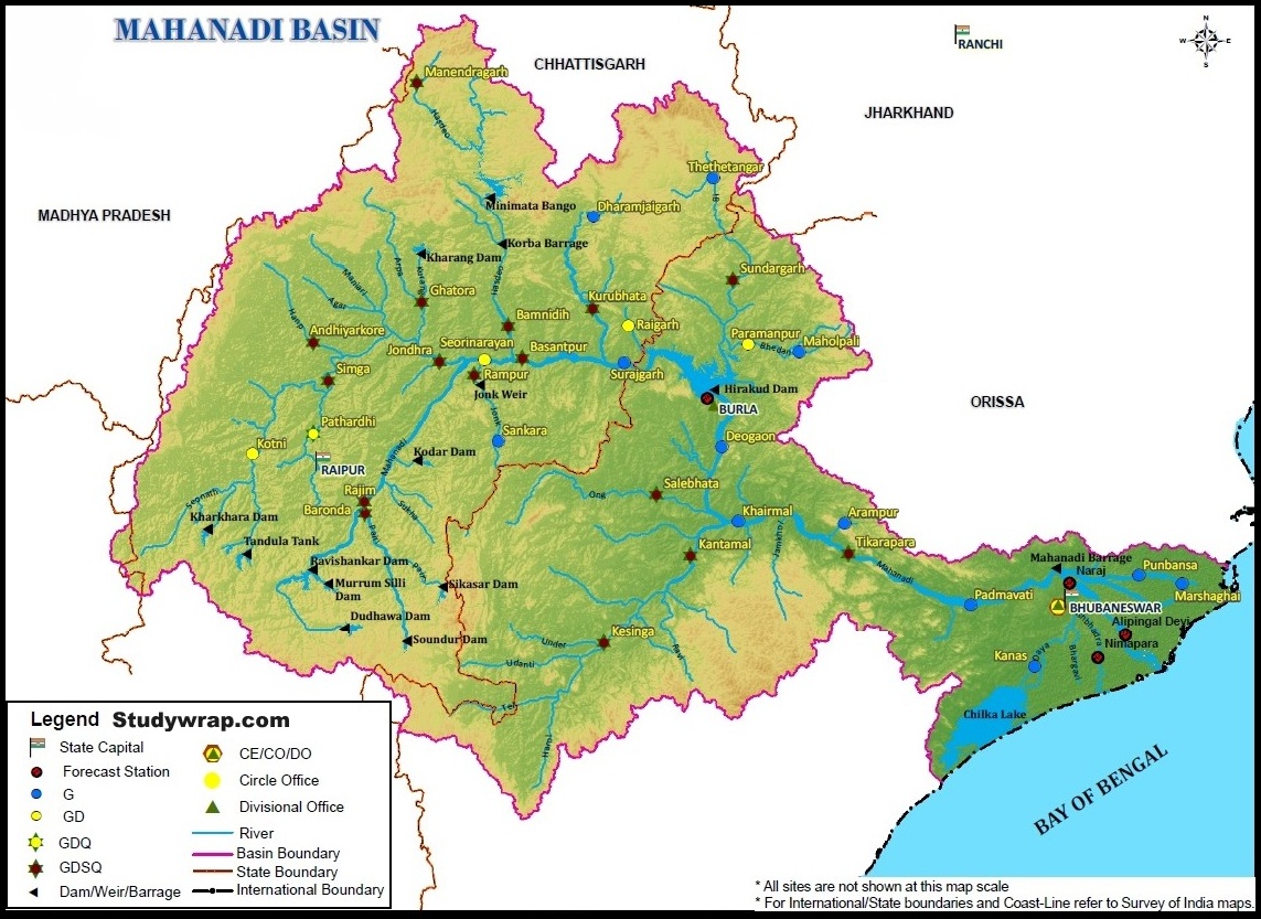
Mahanadi Studywrap.com
|
|
Origin and River Course
|
Tributaries
|
Mineral Resources
|
- Origin – originates in the northern hills of Dandakaranya Raipur district of Chhattisgarh at an elevation of 442 m.
- Basin extends from state of Chhattisgarh, Orissa and small portion of Maharashtra, Jharkhand and Madhya Pradesh.
- Bounded by central Indian hills on the north, by the Eastern Ghats on the south and east and by Maikal range on the west.
- Total Length – 900 km
- One of the most active silt depositing stream in Indian subcontinent.
- The Mahanadi is one of the major rivers of East Flowing Peninsular Rivers, in water potential and flood producing capacity, it ranks second to the Godavari.
- Other small streams between the Mahanadi and the Rushikulya draining directly into the Chilka Lake also forms the part of the basin.
- After receiving the Seonath River, it turns east and enters Odisha state.
- At Sambalpur the Hirakud Dam on the river has formed a man-made lake 35 miles (55 km) long.
- It enters the Odisha plains near Cuttack and enters the Bay of Bengal at False Point by several channels.
|
- Its upper course lies in saucer shaped basin called Chhattisgarh plains.
- This basin is surrounded by hills on north, west and south as a result large no. of tributaries joins the main river from these sides.
- Left Bank Tributaries – Seonath, Hasdeo, Mand, Ib
- Right Bank Tributaries – Ong, Telm Jonk.
|
|
|
Industries
|
Projects
|
Floods and Droughts
|
- Three important urban centres in the basin are Raipur, Durg and Cuttack.
- Mahanadi basin, because of its rich mineral resource and adequate power resource, has a favourable industrial climate.
- The Important industries presently existing in the basin are the Iron and Steel plant at Bhilai, aluminium factories at Hirakud and Korba, paper mill near Cuttack and cement factory at Sundargarh.
- Other industries based primarily on agricultural produce are sugar and textile mills.
- Mining of coal, iron and manganese are other industrial activities.
|
- Two important projects of pre plan period in the basin are the Mahanadi main canal and Tandula reservoir in Chhattisgarh.
- During the plan period, the Hirakud dam, Mahanadi
delta project, Hasdeo Bango, Mahanadi Reservoir Project were completed.
|
- The basin is subject to severe flooding occasionally in the delta area due to inadequate carrying capacity of the channels.
- The multi-purpose Hirakud dam provides some amount of flood relief by storing part of flood water.
- However, the problem still persists and a lasting solution need to be evolved.
|
2. Godavari

|
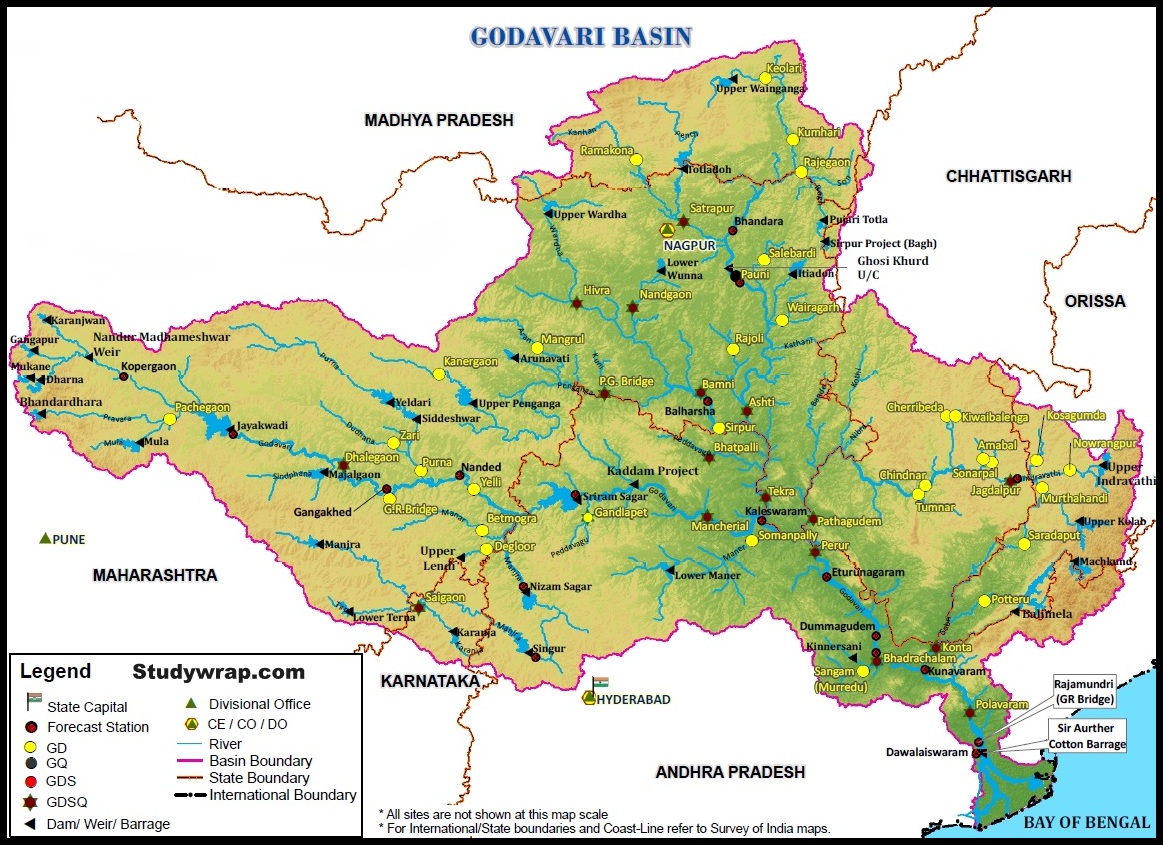
Godavari Studywrap.com
|
|
Origin and River Course
|
Tributaries
|
Mineral Resources
|
- Origin – rises from Trimbakeshwar in the Nashik district of Maharashtra about 80 km from the Arabian Sea at an elevation of 1,067 m.
- The Godavari is the largest river system of the Peninsular India and is revered as Dakshina Ganga.
- The Godavari basin extends over states of Maharashtra, Andhra Pradesh, Chhattisgarh and Odisha in addition to smaller parts in Madhya Pradesh, Karnataka and Union territory of Puducherry having a total area of ~ 3 lakh Sq.km.
- The basin is bounded by Satmala hills, the Ajanta range and the Mahadeo hills on the north, by the Eastern Ghats on the south and the east and by the Western Ghats on the west.
- Total length – 1465 km.
- Navigable in Deltaic Stretches.
- River after Rajahmundry splits into several branches forming large Delta.
|
- The left bank tributaries are more in number and larger in size than the right bank tributaries.
- The Manjra (724 km) is the only important right bank tributary. It joins the Godavari after passing through the Nizam Sagar.
- Left Bank Tributaries: Dharna, Penganga, Wainganga, Wardha, Pranahita [conveying the combined waters of Penganga, the Wardha and Wainganga], Pench, Kanhan, Sabari, Indravati etc.
- Right Bank Tributaries: Pravara, Mula, Manjra, Peddavagu, Maner etc.
- Below Rajahmundry, the river divides itself into two main streams, the Gautami Godavari on the east and the Vashishta Godavari on the west and forms a large delta before it pours into the Bay of Bengal.
- The delta of the Godavari is of lobate type with a round bulge and many distributaries.
|
- Upper reaches of the Godavari basin are occupied by the Deccan Traps containing minerals like magnetite, epidote, biotite, zircon, chlorite etc. (metallic minerals).
- The middle part of the basin is principally composed of phyllites, quartzite, amphiboles and granites (rocks).
- The downstream part of the middle basin is occupied mainly by sediments and rocks of the Gondwana group.
- The Gondwana are principally detrital (waste or debris, in particular organic matter produced by decomposition or loose matter produced by erosion) with some thick coal seams. [Singareni Coal Seam]
- The Eastern Ghats dominate the lower part of the drainage basin and are formed mainly from the Khondalites.
|
|
Industries
|
Projects
|
Floods and Droughts
|
- Major urban Centres in the basin are Nagpur, Aurangabad, Nashik, and Rajahmundry.
- Nashik and Aurangabad have large number of industries especially automobile.
- Other than this, the industries in the basin are mostly based on agricultural produce such as rice milling, cotton spinning and weaving, sugar and oil extraction.
- Cement and some small engineering industries also exist in the basin.
|
- Important projects completed during the plan period are Srirama Sagar, Godavari barrage, Upper Penganga, Jaikwadi, Upper Wainganga, Upper Indravati, Upper Wardha.
- Among the on-going projects, the prominent ones are Prnahita-Chevala and Polavaram.
|
- Godavari basin faces flooding problem in its lowerreaches.
- The coastal areas are cyclone-prone.
- The delta areas face drainage congestion due to flat topography.
- A large portion of Maharashtra falling (Marathwada) in the basin is drought prone.
|
3. Krishna

|
Krishna Studywrap.com
|
|
Origin and River Course
|
Tributaries
|
Mineral Resources
|
- Origin – rises from the Western Ghats near Jor villageof Satara district of Maharashtra at an altitude of 1,337 m just north of Mahabaleshwar.
- The Krishna is the second largest East Flowing Peninsular Rivers.
- The Krishna Basin extends over Andhra Pradesh, Maharashtra and Karnataka having a total area of ~2.6 lakh Sq.km.
- It is bounded by Balaghat range on the north, by the Eastern Ghats on the south and the east and by the Western Ghats on the west.
- The total length of river from origin to its outfall into the Bay of Bengal is 1,400 km.
- The major part of basin is covered with agricultural land accounting to 75.86% of the total area.
- The Krishna forms a large delta with a shoreline of about 120 km. The Krishna delta appears to merge with that formed by the Godavari and extends about 35 km into the sea.
|
- Right bank: the Ghatprabha, the Malprabha and the Tungabhadra.
- Left Bank: the Bhima, the Musi and the Munneru.
- The Koyna is a small tributary but is known for Koyna Dam. This dam was perhaps the main cause of the devastating earthquake in 1967 that killed 150 people.
- The Bhima originates from the Matheron Hills and joins
the Krishna near Raichur after for a distance of 861 km.
- The Tungabhadra is formed by the unification of the Tunga and the Bhadra originating from Gangamula in the Central Sahyadri. Its total length is 531 km.
- At Wazirabad, it receives its last important tributary, the Musi, on whose banks the city of Hyderabad is located.
|
- The basin has rich mineral deposits and there is good
potential for industrial development.
- Iron and steel, cement, sugar cane vegetable oil extraction and rice milling are important industrial activities at present in the basin.
- Recently oil has been struck in this basin which is bound to have an effect on the future industrial scenario of this basin.
|
|
Industries
|
Projects
|
Floods and Droughts
|
- The major Urban Centres in the Basin are Pune, Hyderabad.
- Hyderabad is the state capital of Telangana and is now a major IT hub.
- Pune in Maharashtra has number of automobile and IT industry and is major education centre.
|
- Important ones are the Tungabhadra,Ghatprabha, Nagarjunasagar, Malprabha, Bhima, Bhadra and Telugu Ganga.
- The major Hydro Power stations in the basin are Koyna, Tungabhadra, Sri Sailam, Nagarjuna Sagar, Almatti, Naryanpur, and Bhadra.
- Tungabhadra is a major inter-States project in the basin. In order to operate the project and to regulate the flows among the beneficiary States of Karnataka and Andhra Pradesh.
|
- Some parts of the basin, especially the Rayalaseema area of Andhra Pradesh, Bellary, Raichur, Dharwar, Chitradurga, Belgaum and Bijapur districts of Karnataka and Pune, Sholapur, Osmanabad and Ahmedanagar districts of Maharashtra are drought-prone.
- The delta area of the basin is subject to flooding. It has been observed that the river bed in delta area is continuously raised due to silt deposition resulting in reduction in carrying capacity of the channel.
- The coastal cyclonic rainfall of high intensity and short duration makes the flood problem worse.
|
4. Cauvery

|
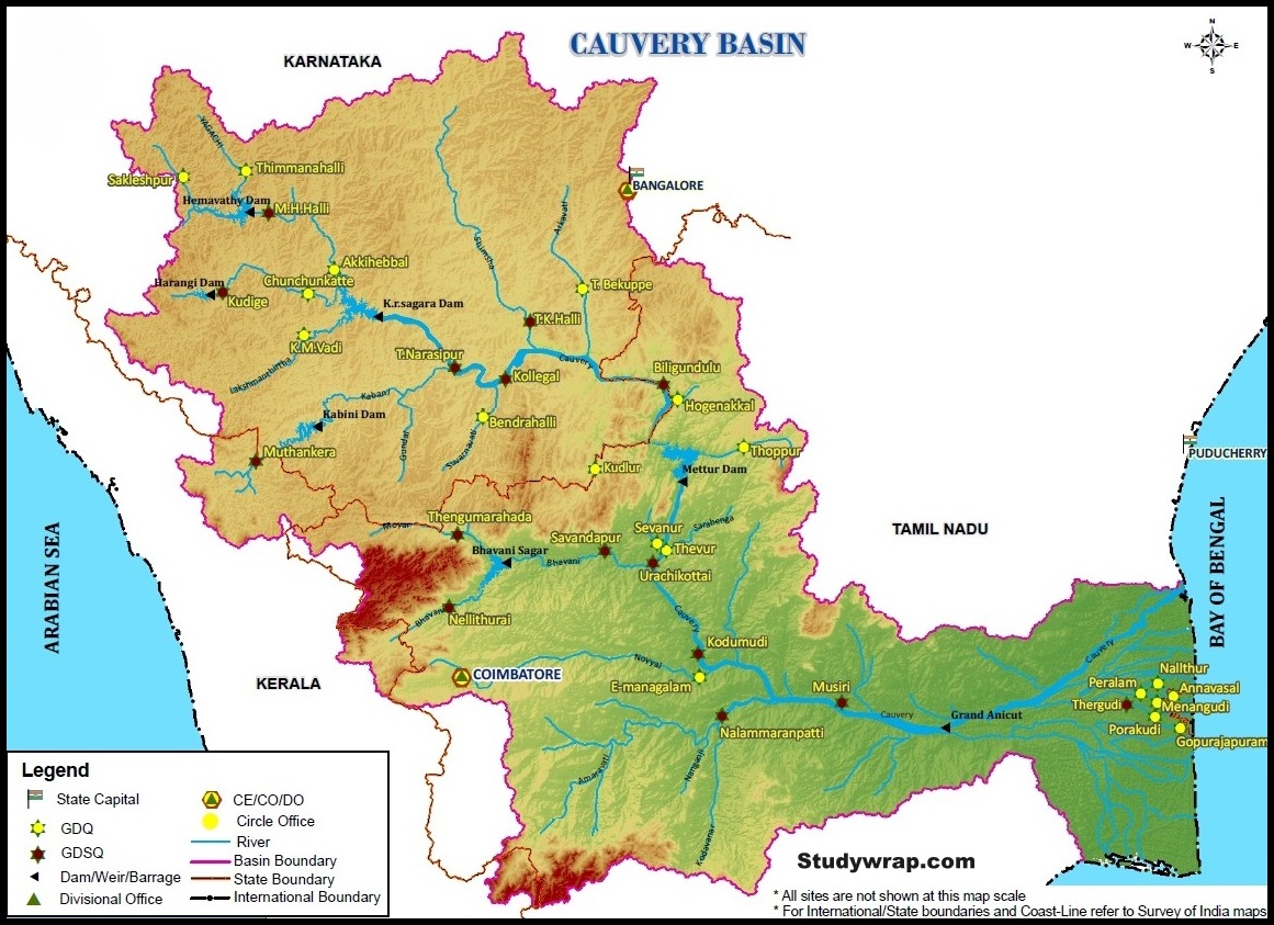
Cauvery Studywrap.com
|
|
Origin and River Course
|
Tributaries
|
Mineral Resources
|
- Origin – rises at an elevation of 1,341 m at Talakaveri on the Brahmagiri range near Cherangala village of Kodagu (Coorg), Karnataka.
- Total length – 800 km.
- The Cauvery basin extends over states of Tamil Nadu, Karnataka, Kerala and Union Territory of Puducherry draining an area of 81 thousand Sq.km.
- Bounded by the Western Ghats on the west, by Eastern Ghats on the east and the south and by ridges separating it from Krishna basin and Pennar basin on the north.
- The Nilgiris extend Eastwards to the Eastern Ghats and divide the basin into two natural and political regions i.e., Karnataka plateau in the North and the Tamil Nadu plateau in the South.
- Physiographically, the basin can be divided into three parts – the Western Ghats, the Plateau of Mysore and the Delta.
- The delta area is the most fertile tract in the basin. Alluvial soils are found in the delta areas.
- The basin in Karnataka receives rainfall mainly from the S-W Monsoon and partially from N-E Monsoon. The basin in Tamil Nadu receives good flows from the North-East Monsoon.
- Its upper catchment area receives rainfall during summer by the south-west monsoon and the lower catchment area during winter season by the retreating north-east monsoon.
- It is, therefore almost a perennial river with comparatively less fluctuations in flow and is very useful for irrigation and hydroelectric power generation.
- The river drains into the Bay of Bengal. The major part of basin is covered with agricultural land accounting to 66.21% of the total area.
|
- Left Bank: the Harangi, the Hemavati, the Shimsha and
the Arkavati.
- Right Bank: Lakshmantirtha, the Kabbani, the Suvarnavati, the Bhavani, the Noyil and the Amaravati joins from
right.
- The river descends from the South Karnataka Plateau to the Tamil Nadu Plains through the Sivasamudram waterfalls (101 m high).
- At Sivasamudram, the river branches off into two parts and falls through a height of 91 m in a series of falls and rapids.
- At Hogennekkal Falls, it takes Southerly direction and enters the Mettur Reservoir.
- A tributary called Bhavani joins Cauvery on the Right bank about 45 km below Mettur Reservoir. Thereafter it enters the plains of Tamil Nadu.
- Two more tributaries Noyil and Amaravati join on the right bank and here the river widens with sandy bed and flows as ‘Akhanda Cauvery’.
- After crossing Tiruchirappalli district, the river divides into two parts, the Northern branch being called ‘The Coleron’ and Southern branch remains as Cauvery and from here the Cauvery Delta
begins.
- Below the Grand Anicut, the Cauvery branch splits into two, Cauvery and Vennar.
- These branches divide and sub-divide into small branches and form a network all over the delta.
|
|
|
Industries
|
Projects
|
Floods and Droughts
|
- Bangalore is situated just outside this basin.
- Important industries in the basin include cotton textile industry in Coimbatore and Mysore, cement factories in Coimbatore and Tiruchirappalli and industries based on mineral and metals.
- The Salem steel plant and many engineering industries in Coimbatore and Tiruchirappalli are also situated in this basin.
|
- During the pre-plan period many projects were completed in this basin which included Krishna rajasagar in Karnataka, Mettur dam and Cauvery delta system in Tamil Nadu.
- Lower Bhavani, Hemavati, Harangi, Kabbani are important projects completed during the plan period.
|
- The Cauvery basin is fan shaped in Karnataka and leaf shaped in Tamil Nadu.
- The run-off does not drain off quickly because of its shape and therefore no fast raising floods occur in the basin.
|
5. Pennar

|
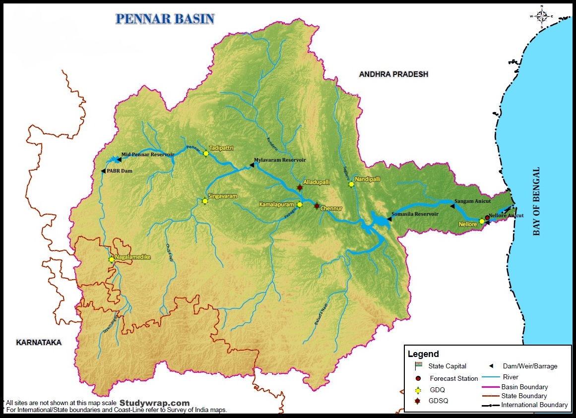
Pennar Studywrap.com
|
|
Origin and River Course
|
Tributaries
|
- The Pennar (also known as Uttara Pinakini) is one of the major East Flowing Peninsular Rivers.
- The Pennar rises in the Chenna Kasava hill of the Nandidurg range, in Chikkaballapura district of Karnataka and flows towards east eventually draining into the Bay of Bengal.
- The total length of the river from origin to its outfall in the Bay of Bengal is 597 km.
- Located in peninsular India, the Pennar basin extends over states of Andhra Pradesh and Karnataka having an area of ~55 thousand Sq.km
- The fan shaped basin is bounded by the Erramala range on the north, by the Nallamala and Velikonda ranges of the Eastern Ghats on the east, by the Nandidurg hills on the south and by the narrow ridge separating it from the Vedavati valley of the Krishna Basin on the west.
- The other hill ranges in the basin to the south of the river are the Seshachalam [famous for Red Sanders] and Paliconda ranges.
- The major part of basin is covered with agriculture accounting to 58.64% of the total area.
|
- Left Bank: the Jayamangali, the Kunderu
- Right bank: the Chiravati, the Papagni etc.
|
|
Industries
|
Projects
|
Floods and Droughts
|
- The only important town in the basin is Nellore
- With limited water and power potential and mineral resources, the scope for industrial development is limited in the basin.
- There are no major industries. The existing small industries are mostly based on agricultural produce such as cotton weaving, sugar mills, oil mills, rice mills etc.
|
- Tungabhadra high level canal in Krishna basin irrigated areas in Pennar basin also.
- The only major project in the basin is the Somasila project.
|
- The basin lies in a zone of poor rainfall and hence is frequently hit by famine.
- The drought-prone Rayalaseema area of Andhra Pradesh partly lies in this basin.
|
6. Subarnarekha
-
- It originates near Nagri village in Ranchi district of Jharkhand at an elevation of 600 m.
- Total length 395 km.
- It is bounded on the North-West by the Chota Nagpur Plateau, in the South-West by Brahmani basin, in the South by Burhabalang basin.
- Basin extends over States of Jharkhand, Odisha and comparatively smaller part in West Bengal
- It joins Bay of Bengal forming an estuary between Ganga and Mahanadi deltas.
- It forms the boundary between West Bengal and Orissa in its lower course.
- The principal tributaries of the river are Kanchi, Kharkai and Karkari.
- This region contains some of the richest coal and ore deposits like iron and bauxite.
7. Brahmani
-
- The Brahmani, known as the South Koel River in the upper reaches, originates near Nagri village in Ranchi district of Jharkhand at an elevation of about 600m.
- The basin is bounded in the North by Chota Nagpur plateau, in the West and South by the Mahanadi basin and in the East by the Bay of Bengal.
- The basin flows through Jharkhand, Chhattisgarh and Orissa States and draining a total area of 39,033 sq.km.
- Total length – 799 km
- The principal tributaries of this river are Sankh, Tikra and Karo.
- The basin is rich in mineral resources. Coal, Iron ore, Copper, Bauxite, Chromite, Limestone, Manganese, Dolomites, Lead, Fire-clay and China clay are the main mineral resources of this basin.
8. Vaigai
-
- rises on the Eastern slopes of the Varushanadu hills at an elevation on 1,200 m above mean sea level near Kottaimalai in the Madurai district
- Entirely lies in the state of Tamil Nadu.
- Two important tributaries namely, the Suruliyar and the Manjalar
- Basin is bounded by the Varushanadu hills, the Andipatti hills, the Cardamom hills and the Palani hills on the West and by the Palk Strait and Palk Bay on the East.
9. Ponnaiyar
-
- The Ponnaiyar or the Dakshina Pinakini River rises near Hongashenhalli village at an elevation of about 900 m above mean sea level in the Kolar district of Karnataka state.
- Covers a large area in the state of Tamil Nadu besides the areas covered in the states of Karnataka and Andhra Pradesh.
- Basin is bounded on the North -West and South by various ranges of the Eastern Ghats and in the East by the Bay of Bengal.
- The river Ponnaiyar branches into two, the Gadilam and the Ponnaiyar below the Tirukoyilur Anicut. The Gadilam joins the Bay of Bengal near Cuddalore and the Ponnaiyar near the Union Territory of Pondicherry.
So, this was all about the East flowing peninsular rivers of India. If you want to read about the West Flowing Peninsular Rivers than Click Here.
In the next post (Click here), we will discuss about the difference between the Himalayan and Peninsular River System.


Whats the difference between Peninsular drainage and Himalayan Drainage?
Regards… :-)
Loving the information on this web site, you have done great job on the content .
really appreciable work…
I think this information is very useful for my preparation.
Thank you, I am very glad to see such information in tabular form which I was searching for a long time.
i think Godavari is regarded as ganga of the south not Cauvery..right?
Very informative post. Looking more to something similar to this.