
Mountain Ranges of India
Mountain Ranges of India
Table of Contents
What is Mountain Range?
- A Mountain Range is a sequential chain or series of mountains or hills with similarity in form, structure, and alignment that have arisen from the same cause, usually an orogeny.
- A mountain range is a series of mountains stretched in a line and joined by high ground. Mountain ranges are usually segmented by highlands or mountain passes and valleys.
- India has some of the highest mountain ranges and mountain roads in the world. India is home to seven major mountain ranges that have peaks of over 1000 metres.
- The most famous and the highest mountain range of India is the Himalayan range. It is also the youngest and the longest mountain range in India and has almost every largest peak of the world.
Mountain Ranges of India
-
- India has some of the highest mountain ranges in the world.
- It also has some of the world’s highest mountain roads.
- The Great Himalayan mountain ranges are the famous and highest mountain hills of India.
- The Himalayan mountain range bisects India from the rest of Asia, this mountains is the primary source of mighty rivers in India.
- These mountain ranges in India are treasure troves of natural resources. They travel through the entire length and breadth of the Indian subcontinent. These are not just homes to the numerous flora and fauna but have also played a vital role in shaping the culture, tradition, and economy of the regions surrounding them.
List of Mountain Ranges of India
|
Range |
States |
Description |
|
HIMALAYA RANGE |
Northern India |
Great Himalaya Range · Rising more than 22,000 feet above sea level and with the stretch of over 1,200 miles along India’s northern border. · It has Kanchenjunga, the third-highest peak in the world. Middle Himalaya Range · An elevation of about 5,000 to 20,000 feet above sea level. · There are two major mountain ranges in the Middle Himalaya—the Pir Panjal Range and Dhauladhar Range. Outer Himalaya/Shivalik Range · Consists of valleys and hills that rise no more than about 5,000 feet above sea level. · A large part of the range is located in Himachal Pradesh. |
|
Karakoram Range |
Ladakh |
· A sub range of the Hindu Kush Himalayan Range · It is a Trans- Himalayan Mountain starts from the Pamir Knot. · K2, the second highest peak in the world is located here. · Heavily glaciated part of the world outside the Polar Regions. · Famous Glaciers – Siachen Glacier, Biafo Glacier. · Karakoram Range span the borders between Pakistan, India and China. · Located in the regions of Gilgit – Baltistan (Pakistan), Ladakh (India) and Xinjiang region (China). |
|
Ladakh Range |
Ladakh |
· South eastern extension of the Karakoram Range. · Runs parallel to the Indus River from the mouth of the Shyok River in Ladakh in the west to the border with Tibet in the east. · Extension of the Ladakh Range into China is known as Kailash Range · India’s cold desert named as LEH lies here at its southern edge. · Khardung La Pass is located on it. |
|
Zaskar Range |
Jammu & Kashmir, Ladakh, Uttarakhand |
· Trans-Himalayan or Tibetan Himalayan range located between the Great Himalayas and the Ladakh Range. · Boundary line between Ladakh and remaining two regions i.e. Jammu region and Vale of Kashmir. · Highest peak Kamet (UK). · Lies here Coldest place in India, Dras (The Gateway to Ladakh) · Famous Passes – Shipki, Lipu Lekh, and Mana Pass •Nanga Parbat forms its culmination in the northwest |
|
Pir Panjal Range |
Jammu & Kashmir, Ladakh |
· Westernmost range of the Lesser Himalayas which separates Jammu from Kashmir. · Separates Jammu Hills to the south from the Vale of Kashmir (Kashmir Valley), beyond which lie the Great Himalayas. · Extends from the Jhelum River to the upper Beas River for 300-400km. · Highest Point – Indrasan, 2nd Highest – Deo Tibba · Has India’s longest rail tunnel known as Pir Panjal Railway Tunnel, Banihal road tunnel (Jawahar Tunnel) · Famous Passes – Pir Panjal Pass, Banihal Pass, and Rohtang pass. |
|
Dhauladhar Range (White Range) |
Jammu & Kashmir, Ladakh, Himachal Pradesh |
· Southernmost range of the Lesser Himalayas in Jammu and Kashmir and Himachal Pradesh. · Spread in J & K and Himachal, with home to major hill stations like Kullu, Manali & Shimla. · Highest peak – Hanuman ji Ka Tiba, or ‘White Mountain‘ · Hill Stations -Dalhousie, Chamba, Kullu, Manali, Botata, Dharmshala, Shimla · Southern slope is steeper than the northern slope. |
|
Nag Tibba |
Uttarakhand |
· Part of the Lesser Himalaya in the southwestern Uttarakhand. · Nag Tibba (3022m) is its highest peak. · Most easterly of the ranges of the Lesser Himalayas in India. · Hill Station– Mussoorie. |
|
Shivalik Range |
|
· The Shivalik Hills, also known as Churia Hills, are a mountain range of the outer Himalayas. · Also known as Manak Parbat in ancient times, literally means ‘tresses of Shiva’. · About 2,400 km long from Indus till Brahmaputra, with a gap of about 90 km between the Teesta and Raidak rivers in Assam known as sub Himalayas. · Consists of valleys and hills that rise no more than about 5,000 feet above sea level. · A large part of the range is located in Himachal Pradesh. |
|
Kumaon Range |
Uttarakhand |
· Part of the Lesser Himalayas in the south-eastern part of Uttarakhand. |
|
PURVANCHAL RANGE
|
|
· The Purvanchal Mountains cover the states of Assam, Arunachal Pradesh, Manipur, Tripura, Nagaland, Meghalaya and Mizoram. · The average height of peaks in this range is about 9,845 feet above sea level. · The highest is the Dapha Bum. |
|
Garo, Khasi, Jaintia Hills |
|
· Continuous mountain range in Meghalaya |
|
Garo Hills |
Meghalaya |
· Westernmost part of the Meghalaya Plateau. · Inhabited by the Garo tribes. · Nokrek Biosphere Reserve situated Here. · Tura is the main city in the region. · Highest peak- Nokrek. |
|
Khasi Hills |
Meghalaya |
· Middle part of the Meghalaya Plateau. · Highest point of the Meghalaya Plateau. · Cherrapunjee and Mawsynram are located in it. · Shillong is located in the hill. · Inhabited by the matrilineal Khasi tribes. |
|
Jayantiya Hills |
Meghalaya |
· Eastern part of the Meghalaya Plateau. · Inhabited by the Jayantiya tribes. · Jhuming cultivation is practised. · High rainfall region. · Presence of the laterite soils. |
|
Patkai Bum Range
|
Arunachal Pradesh |
· Situated on India’s north-eastern border with Burma. · Northernmost range of the Purvanchal, located in Arunachal Pradesh. · Forms boundary between India and Myanmar. · Source of Burhi Dihing and Disang rivers. |
|
Mikir Hills |
Assam |
· Part of the Meghalaya Plateau located in Assam, just south of the Brahmaputra River. · Group of hills located to the south of the Kaziranga National Park (Assam). • Mikir tribes live here who practise Jhum cultivation. • Hills consist of the Archaean rocks. |
|
Dafla |
Arunachal Pradesh |
· Part of the Shivalik located in Arunachal Pradesh · Located between the Subansiri River and the Kameng River, that to the south of the Kamla River. · Tribes living here practice Jhum cultivation. · Covered with dense bamboo, pine and deodar trees. |
|
Naga Hills |
Nagaland |
· Part of the Purvanchal. · Located between the Patkai Bum and the Manipur Hills in Nagaland. · Highest peak- Saramati (3826m) · Forms boundary between India and Myanmar. |
|
Abor Hills |
Arunachal Pradesh |
· Hills of Arunachal Pradesh, near the border with China, bordered by Mishmi and Miri Hills. · Drained by Dibang River, a tributary of the Brahmaputra. · Located in Arunachal Pradesh between the Dibang and the Subansiri river. · Covered with deciduous and evergreen forests. Inhabited by the tribal peoples. · Highest peak is 3992 m above sea level. |
|
Miri Hills |
Arunachal Pradesh |
· Part of the Outer Himalayas (Shivalik) in Arunachal Pradesh. · Located between the Subansiri River and the Kameng River that to the north of the Kamla River which separates it forms the Dafla Hills. · Inhabited by tribes. · Terraces are built for the cultivation. |
|
Mishmi Hills |
Arunachal Pradesh |
· Easternmost part of the Shivalik. · Located in northeast Arunachal Pradesh from the Dibang River (West) to the Myanmar border in the east and eastern parts touching China. · Situated at the junction of North eastern Himalaya and Indo-Burma ranges. · Dibang River flows through it. |
|
Mizo Hills (Lushai Hills) |
Mizoram, Tripura |
· Southernmost part of the Purvanchal, also known as the Lusai Hills. · Part of the Patkai range in Mizoram and partially in Tripura. · Highest peak – 2,157 m high Phawngpui or Blue Mountain. · Crossed by the Tropic of Cancer. |
|
Manipur Hills |
Manipur |
· Part of the Purvanchal in Manipur. · Loktak Lake is located in it. · Manipur River originates here. · Forms boundary between India and Myanmar. |
|
VINDHYA RANGE |
Madhya Pradesh, Gujarat, Uttar Pradesh and Bihar
|
· The Vindhya Range (also known as Vindhyachal) is a complex, discontinuous chain of mountain ridges, hill ranges, highlands and plateau escarpments in west-central India. · The general elevation of the Vindhya Range is around 980-2,100 feet above sea level, with peaks rarely going over 2,300 feet. · Highest peak – Sadbhawna Shikhar |
|
SATPURA RANGE |
Madhya Pradesh, Gujarat, Maharashtra, Chhattisgarh |
· A range of hills in central India. · The range rises in eastern Gujarat state running east through the border of Maharashtra and Madhya Pradesh to the east till Chhattisgarh. · Passes through Madhya Pradesh, Gujrat, Maharashtra, Chhattisgarh · Highest peak – Dhupgarh |
|
ARAVALLI RANGE |
Gujarat, Rajasthan, Haryana & Delhi |
· Old dissected mountains of north western India. · Means ‘line of peaks’, runs across Gujarat, Rajasthan, Haryana & Delhi. · Highest Peak – Gurushikhar, Mt Abu · Famous passes – Pipli Ghat, Haldi Ghat · Locally known as Mewar hills · Source of Banas, Luni and Sabarmati rivers · Rich in non- ferrous minerals |
|
Abu Hills |
Rajasthan |
· The southwestern part of the Aravalli Range, between the Sabarmati and the Banas Rivers. · Mount Abu is located on it. |
|
Maikal Range |
Madhya Pradesh Chhattisgarh |
· Eastern part of the Satpura Range. · Located between Madhya Pradesh and Chhattisgarh. · Source of many tributaries of Narmada, Mahanadi and Godavari. · Inhabited by the tribal peoples like Baiga and Gond. · Kanha National Park, Achanakmar-Amarkantak Biosphere Reserve are situated here. |
|
Kaimur Range |
MP, UP & Bihar |
· Eastern portion of the Vindhya Range in MP, UP & Bihar, · Located between the Son and the Tons rivers in north eastern Madhya Pradesh. · Its northern edge forms escarpments. · Prehistoric rock paintings have been discovered here. |
|
Mahadeo Range |
Madhya Pradesh |
· Forms the central part of the Satpura Range. · Highest peak – Dhoopgarh · Watershed between Narmada and Godavari. · Origin of the Tapi River. |
|
Ramgarh Hills |
Chhattisgarh, Jharkhand |
· Hills of the north eastern Chhattisgarh, adjoining Jharkhand. · Source of Rihand, Sankh and Mand and Ib rivers. · Main city is Ambikapur. |
|
Ajanta Range |
Maharashtra |
· A mountain range of Maharashtra entirely within the state Maharashtra. · Situated South of river Tapi. · Sheltering caves of world famous paintings of Gupta period. · Forms the watershed between the Godavari and the Tapi river systems · Source of Purna and Penganga River. · Ajanta Caves are located. |
|
Satmala Range |
Maharashtra |
· Branch the northern Western Ghats in the northwest Maharashtra |
|
Nirmal Range |
Maharashtra |
· A low hill of Maharashtra located between Penganga and Godavari rivers. · Nanded city is located on it. |
|
Rajmahal Hills |
Jharkhand |
· In Jharkhand made up of lava basaltic rocks. · Point of Ganges bifurcation. |
|
Dalma Hills |
Jharkhand |
· Located in Jamshedpur. · Famous for Dalma national park & minerals like iron ore & manganese. |
|
Mandav Hills |
Madhya Pradesh, Gujarat, Rajasthan |
· Hills of the central Kathiawar · Forms a radial drainage pattern · Main city – Rajkot · Covered with the basaltic lava |
|
Gir Hills |
Gujarat |
· Low hills of the Kathiawar Peninsula to the southeast of the Girnar Hills. · Highest Peak – Sarkala (643m) · The Gir National Park is located in the region. |
|
Girnar Hills |
Gujarat |
· Collection of mountains in the Junagarh district, in the Kathiawar. · Girnar Peak (945m) is highest peak of Gujarat. · The Gir National Park is located in the region. · Holy place for both Hindus and Jains. |
|
Rajpipla Hills |
Gujarat |
· The westernmost part of the Satpura Range, mainly in eastern Gujarat, around the city of Rajpipla. · Separated from the Gawilgarh Hills by the Khandwa Gap. |
|
WESTERN GHATS |
|
· Made up of multiple mountain ranges, with more than 70 peaks. · Varying in height from 1,713 feet to 8,842 feet above sea level.
|
|
EASTERN GHATS |
Odisha, Andhra Pradesh, Telangana, Tamil Nadu, Karnataka, Kerala |
· The Eastern Ghats are a discontinuous range of mountains along India’s eastern coast. · The Eastern Ghats run from the northern Odisha through Andhra Pradesh to Tamil Nadu in the south passing some parts of Karnataka and in the Wayanad district of Kerala. · They are eroded and cut through by four major rivers of peninsular India, viz. Godavari, Mahanadi, Krishna, and Kaveri. · It has peaked over 3,280 feet above sea level though, mainly in the Maliya Range in Odisha and Madugula Konda Range in Andhra Pradesh. · The highest is Jindhagada Peak in Andhra Pradesh, with an elevation of 5,545 feet. |
|
Baba Budan Giri |
Karnataka |
· Part of the Western Ghats in the Chikamangaluru District of Karnataka. · Highest peak- Mullayangiri · Baba Budan was a 17th century sufi, who is believed to have introduced coffee in India. · Known for coffee cultivation. |
|
Harishchandra Hills |
Maharashtra |
· Eastward spur of the Western Ghats, in Maharashtra. · Average elevation – 600m. · Elevation gradually decreases towards the southeast. · Flat topped Hills, consisting of basaltic lava. · At Pune, acts as a water divide bw Godavari & Krishna. · Slops are eroded into terraces. · Named after Harishchandragarh, its highest peak. · Ahmednagar is the chief city in the region. |
|
Balaghat range |
MP & Maharashtra |
· Series of hills in western Maharashtra originates from the Western Ghats. · Extends for 200 miles to form border between Maharashtra and Karnataka. · Flat topped hills with lava covers. · Source of Manjra River. · Famous for manganese deposits. · Rainier west has dense vegetation but the eastern part is barren and stony. |
|
Talcher series |
Odisha |
· Odisha, rich in bituminous coal |
|
Garhjat Hills |
Odisha, Jharkhand, |
· The Garhjat Hills is a mountain range formed by a series low lying hills, plateaux, ridges and meadows. · Stretch into Odisha from the Utkal Plains in the Chotanagpur region of Jharkhand and the Chhattisgarh Plains. · Mayurbhanj and Keonjhar come under it. · Famous for iron ores. · Several Gond tribes live here. · Highest peak – Malaygiri (1187m). |
|
Bailadila range |
Chhattisgarh |
· Bailadila Range, is a mountain range rising in the Deccan Plateau about 200 km west of the Eastern Ghats. · It has been named ‘Bailadila’ because it resembles the hump of an ox. · It is located near Kirandul town in the Dantewada district of southern Chhattisgarh, India. |
|
Champion series |
Karnataka |
· Karnataka, Dharawar period. · rich in gold (contains kolar mines) |
|
Nagari Hills |
Andhra Pradesh |
· Southernmost part of Andhra Pradesh, west of the Pulicat Lake in Chittur District. · Main city – Nagari · ‘Nag’ means nose in Telugu · Highest cliff- Nagari Nose |
|
Velikonda Range |
Andhra Pradesh |
· Part of the Eastern Ghats. Southeast of Andhra Pradesh, east of the Nallmalla Hills. · Strongly folded and faulted. · Assumed to be elevated during the Cambrian Period, now a relict range. · Chenchu tribal people live here. · Parallel to the Coromandel Coast. · Crossed by the Penneru River. |
|
Melagiri Range |
Karnataka and Tamil Nadu |
· Range of hills, part of the Eastern Ghats. · Melagiri Sanctuary is located here. · Arkaveti River flows through the range. · Hosur city, Bennerghatta NP and Kolar gold fields are near to it. |
|
Nilgiri Hills |
Tamil Nadu, Karnataka and Kerala |
· Referred as Blue mountains, a range of mountains in the westernmost part of Tamil Nadu at the junction of Karnataka and Kerala. · Hills are separated from the Karnataka plateau to the north by the Moyar River and from the Anaimalai Hills & Palni Hills to the south by the Palghat Gap – Trijunction of Tamil Nadu, Kerala and Karnataka, north of the Palghat. · Meeting point of the Eastern and Western ghats. · Nilgiri Biosphere Reserve and other conservation areas. · Highest peak – Doddabetta, 4 km from Otty. |
|
Palani Hills |
Tamil Nadu |
· Eastward extension of the Western Ghats ranges. · Adjoin the high Anamalai range on the west, and extend east into the plains of Tamil Nadu. · North of Vaigai River. · Mostly within Dindigul district. · Hill station – Kodaikanal. |
|
Anamalai Hills |
Kerala and Tamil Nadu |
· Also known as Elephant Hill. · Located between Kerala and Tamil Nadu, south of the Palghat Gap. · Highest peak – Anaimudi (Idukki district, Kerala). · Many sanctuaries and parks and have many Trekking destination. · Tea, coffee, rubber cultivation and teak forests. |
|
Cardmom Hills |
Kerala and Tamil Nadu |
· Part of the southern Western Ghats, located in southeast Kerala and southwest Tamil Nadu. · Named after the cardamoms which are grown here, beside pepper and coffee. · Has the Shencottah Gap. · Act as Climatic barrier, source of many rivers. · Have many forest reserves for ecological conservation. |
|
Varushnad Hills |
Tamil Nadu |
· South of the Vaigai River and southwest of Madurai, up to the Cardamom Hills. · Eastern offshoot of the Western Ghats. · Cumbum Valley (Vaigai) divides it from the Western Ghats. · Source of Arjuna and Gunnar rivers. |
|
Sirumalai Hills |
Tamil Nadu |
· Between Vaigai (S) and Kaveri in Tamil Nadu. · Source of Valiyar and Manimuttar rivers. · Dindigul is the main city nearby it. · Hill station – Sirumalai. |
|
Shevroy Hills |
Tamil Nadu |
· Between Vellar and Ponnaiyar rivers in Tamil Nadu. · Around Salem city. · Sanatorium and several old coffee plantations. · Source of Turunanimuttai, Vellar, Gomukha and Manimukta rivers. |
|
Javadi Hills |
Tamil Nadu |
· Northern Tamil Nadu in Vellar district. · Between Ponnaiyar and Palar rivers. · Bisected into eastern and western sections by Cheyyar and Agaram, tributaries of the Palar. · Grains, legumes, oilseeds are chief crops. |
|
Pachamalai Hills |
Tamil Nadu |
· also known as the Pachais. Eastern Ghats in Tamil Nadu. · Panchai mean ‘green’ and malai means ‘hills’. · Between Kaveri and Vellar rivers in Tamil Nadu. · Haven of tribals. · Average elevation – 500m to 1000m. · Namakkal is the main city. |
|
Agasthyamalai Hills |
Kerala and Tamil Nadu |
· The Pothigai Hills, also known as the Shiva Jothi Parvath, Agasthiyar Mountain, Southern Kailash is a 1,866 m tall peak within Kalakkad Mundanthurai Tiger Reserve. · Situated on border of Kerala and Tamil Nadu. |
Some Interesting Facts about Mountain Ranges of India
· The world’s highest mountain range is the Himalayan mountain ranges. It is the longest mountain range in India. It is about 2,400 kilometers long. The most famous Himalayan ranges are the youngest and longest mountain ranges in India. It also has almost every largest peak of the world.
· The Aravalli Mountain ranges are one of the oldest ranges in the world. A major portion of this mountain range lies in Rajasthan.
· There are 7 major mountain ranges in India. They are The Himalayan Mountain Range, The Western Ghats, The Eastern Ghats, The Aravalli Mountain Range, The Karakoram and Pir Panjal Mountain Range, The Purvanchal Mountain Range, The Satpura, and Vindhya Mountain Ranges.
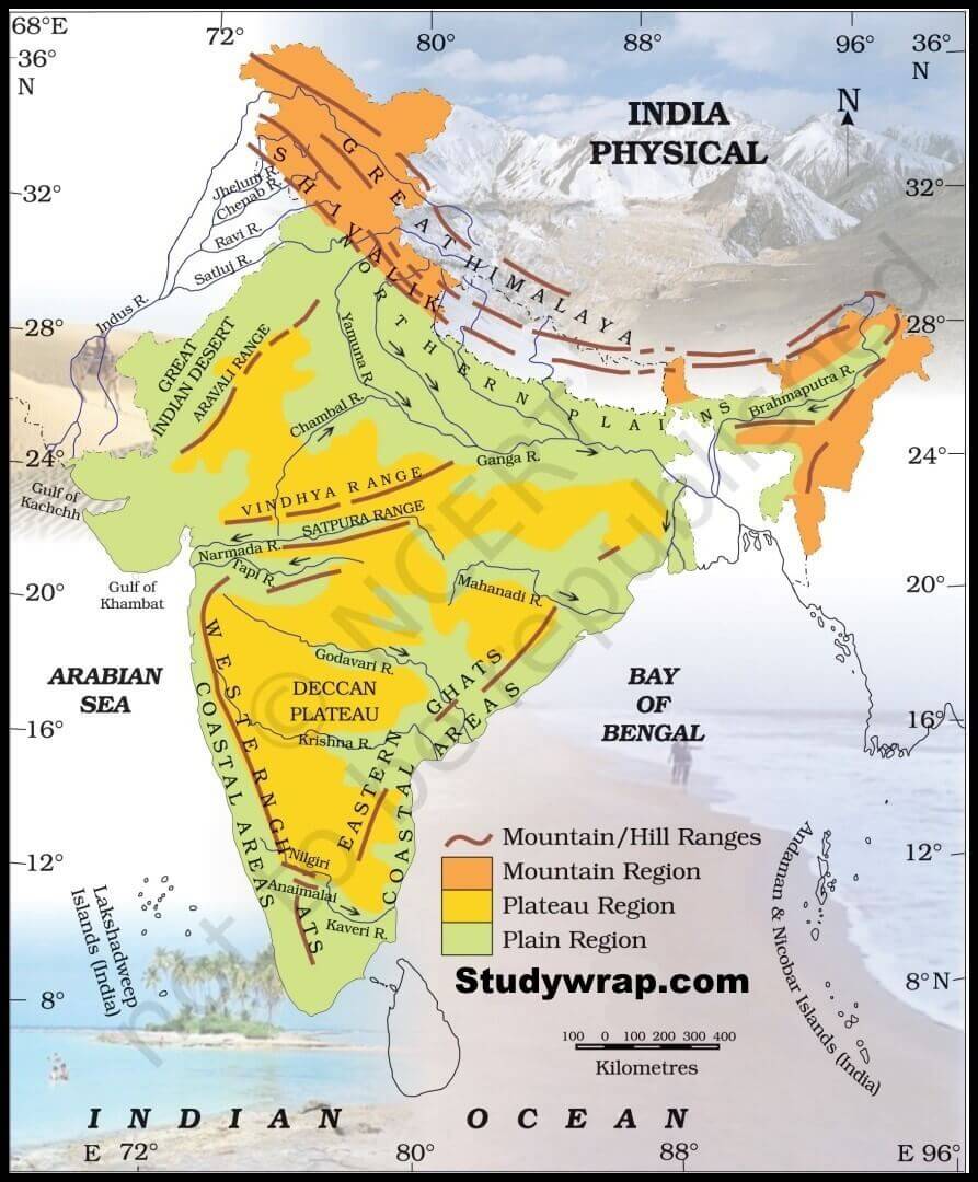
· The two major mountain ranges of South India are the Ghats- the Eastern Ghats and the Western Ghats. These two mountains form the eastern and western edges respectively. These two ranges run roughly parallel to the Bay of Bengal and the Arabian Sea coasts.
So, this is all about the Important Mountain Peaks in India. If you want to read more notes on Indian Geography – Click Here.
In the Next Post (Click Here), we will learn about the Important Mountain peaks in India.
If you Like this Post than please share it with your friends and family and like our Facebook Page to get regular updates. Sharing is Caring J.
