
Geography
Peninsular Plateau – Features & Physiographic Division
The Peninsular Plateau of India & Physiographic Division of Peninsular Plateau of India
Table of Contents
- Ori tvgin of rocks of Peninsular India in 3600 million years ago.
- Before carboniferous period, it was a part of Gondwanaland.
- During the Archean period, the Indian peninsula never subsides under the sea permanently.
- It was more rigid, stable and hair trim and unaffected from mountain building forces.
- However, experience block flaunting and displacement during the subsequent period as evident from the Dharwar and Gondwana formation and fault valley of Narmada Tapi and Son River.
- It was during carboniferous period, coal was formed in Damodar, son, Mahanadi and Godavari basin.
- During cretaceous period, large scale vulcanicity produced Deccan plateau trap comprising Lava sheets of several thousand metre in depth. The Deccan trap originated about 146 million years ago.
Major Geological Formation of Peninsular India
(Or Rock system of Peninsular India)
- About 3600 million years ago
- The plateau of India exhibit a complex system geological structure. It has some of the oldest rock from Precambrian period along with youngest Rock of Holocene epoch.
- The major Rock system found in Peninsular India are –
1. Archean Period
-
-
- Highly crystalline and metamorphosed genesis of Archean period.
- Found in Tamil Nadu, Nilgiri, Karnataka, Andhra Pradesh, Maharashtra, West Bengal, Orissa, Jharkhand, Chhattisgarh, Madhya Pradesh, Meghalaya, Mikir, Bundelkhand And Aravalli.
- Rocks rich in metallic and non-metallic minerals precious stones and building material.
-
2. Dharwar Period
-
-
- Oldest metamorphosed sedimentary rocks found in narrow geosyncline flanking the Archean genesis.
- They occur mainly in
-
- Dharwar, Bellary, Hospet district of Karnataka
- Chota Nagpur plateau
- Upper reaches of Godavari (Durg, Baster, Dantewada etc.)
- Aravalli (Delhi, Rajasthan, Gujarat)
-
- Rocks are rich in iron ore, manganese, copper, mica, zinc, silver, gold, slate, lead, asbestos and limestone.
-
3. Cuddapah System
-
-
- Cuddapah System occupies deep basins of-
-
- Lower valley of Penganga and Godavari
- Talchar series between Mahanadi and Brahmani (Orissa)
- The upper course of Narmada and Son River.
- West of Aravalli near Jodhpur
-
- Rocks rich in building materials, shales, limestones and sandstones.
- Some inferior quality of iron ore, manganese, copper and asbestos are also found.
- Cuddapah System occupies deep basins of-
-
4. Vindhyan System
-
-
- Central Indian Highland also known as Vindhyan range occupies large basin, extending from Chittorgarh in the west to Sasaram in East.
- One branch of it extends from Sasaram to Hosingabad.
- Area stretches over 1 lakh sq. Km from Chambal to Son
- Exposure of sedimentary rocks occurs in Baster area of Chhattisgarh. In some of exposure are found diamond bearing conglomerates.
- The Panna district of Madhya Pradesh and Kurnool district of Andhra Pradesh is well known for diamonds.
- The southern vindhyan is covered by Deccan trap.
- Known for good quality building materials, precious stones, red stone, diamonds etc.
-
5. Gondwana system
-
-
- Coal belt of peninsular India were developed during Carboniferous or Gondwana period.
- Talchar series, Damuda Series, Panchet series are product of this series.
-
6. Deccan Trap
-
-
- Cretaceous System
- The Gondwanaland developed fissure and its broken parts started drifting from each other.
- There was a large scale upheaval of lava from interior of earth to Deccan trap.
- Eruptions of lava is of fissure type.
- This period is marked by transgression of sea and outpouring of huge quantity of basalt so as to form Deccan trap.
- There has been intrusion of plutonic rocks such as gabbro and granite.
- The basalt of Deccan trap is used for road construction and building.
-
7. Tertiary System
-
-
- Final fragmentation of Gondwanaland took place during this period.
- There occurred faulting of Peninsula along with the subsidence of broken block beneath Arabian Sea and Bay of Bengal.
- The tertiary rocks are found on Kathiwada, kuchchh, Laki series (Rajasthan) and along Coromandel Coast and Malabar Coast. In north east found in Meghalaya plateau and Jaintia hills.
-
8. Pleistocene period
-
-
- Deposits are found in lower reaches of Mahanadi, Godavari, Krishna, Kaveri and western coastal plains of Gujarat, Konkan and Malabar.
- More pronounced along eastern coastal plains.
-
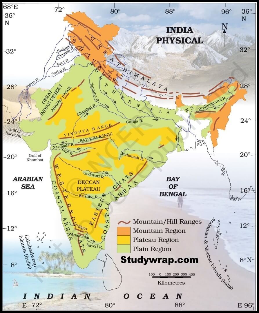
Location and extent
-
- Peninsular plateau lies to south of northern plains of India.
- It is bordered on all sides by the hill ranges –
-
- Delhi ridge in north west
- Rajmahal hills in the east
- Gir range in the west.
- Cardamom hills in the south
-
Constitutes the outer extent of peninsular India.
Geological history
- Peninsular plateau is table land which contains igneous rocks and metamorphic rocks.
- It is one of the oldest and most stable landmass of India.
- In its stable history, some changes occurred like-
-
- Gondwana coal formation
- Narmada and Tapi rift valley formation
- Basalt lava eruption on Deccan plateau
-
- During its journey northward, after breaking off from rest of Gondwanaland, the Indian plate passes through geological hotspot, the reunion hotspot which causes extensive melting underneath the Indian creton.
- The melting broke through the surface of the craton in the massive flood basalt event creating what is known as Deccan trap.
Features of Peninsular India
- Roughly triangular in in shape with its base coinciding with the southern edge to the great Plains of North India.
- Covers the total area of about 16 lakh sq. km.
- Average height of plateau 600 to 900 m above sea level.
1. Rivers
-
-
- Most of Peninsular River flow of west to east integrating its general slope.
- Narmada and Tapi exception which flow from east to west in a rift valley.
-
2. Rock system
-
-
- One on the oldest landform on earth.
- Highly stable block composed of Archean genesis and schists.
- It is been a stable shield which has gone through little structural changes since its formation.
- Since few 100 million years, peninsular block has been a land area and has never been submerged beneath the sea except in few plains.
- Peninsular plateau is aggregation of several smaller Plateau, hill ranges interpreted with river basins and valleys.
-
3. Some important physiological features
-
-
- Tors – Prominent isolated mass of jointed weathered rock, usually granite.
- Spurs – A marked projection of land from a mountain or a ridge.
- Ravines and Gorges – North Western part of plateau has complex relief of ravine and gorges. Eg. Ravines of Bhind, Chambal, Morena.
- Broad and shallow valley and rounded hills.
- Block mountains and rift valleys.
- Bare Rock Structure.
- Series of hummocky hills and wall like quartzite, dykes offering natural site for water storage.
- Deccan Trap – Black soil area between western and north-western part of plateau.
-
Physiographic Division of Peninsular Plateau of India
- On the basis of prominent relief features the peninsular plateau can be divided into three physiographic division of peninsular plateau of India –
-
- The central highlands
- The Deccan Plateau
- The north-eastern plateau
-
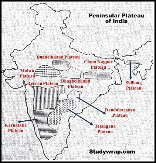
1. The Central Highlands
-
- The part of the peninsular plateau lying to the north of Narmada River covering a major area of Malwa plateau is known as Central highland.
- Metamorphosed area – this region has undergone metamorphic processes in its geological history which can be corroborated by the presence of metamorphic rock such as Marble, slate, gneiss etc.
- Hills and mountains – the Vindhya Range is bounded by the central highland on the south and Aravalli on the Northwest. The further westward extension gradually merges with the Sandy and Rocky desert of Rajasthan. And eastern extension of Central highland is formed by the Rajmahal Hills to the south of which lies a large reserve of mineral resources of Chota Nagpur Plateau.
- Slope – the flow of river drainage in this region is from Southwest to northeast.
- Rivers – Chambal, Betwa, Ken flow towards north and form tributaries of Ganga while Narmada and Tapi drains in West in Arabian Sea. Banās is only significant tributary of jumble that originates from Aravalli in west.
- Boundaries – the eastward extension of this plateau is locally known as Bundelkhand and Baghelkhand. The Chota Nagpur Plateau marks further East ward extension drained by Damodar River. Central highlands are wider invest and narrower in east.
- Narmada valley is the dividing line of Central and Deccan Plateau
- Elevation – 700-1000 m above mean sea level.
- These central highlands consist of –
-
- Marwar upland
- Central plateau
- Bundelkhand upland
- Baghelkhand upland
- Malwa upland
- Chota Nagpur plateau
-
a. Marwar Plateau Or Mewar Plateau
-
-
-
- It is situated in eastern Rajasthan. Marwar plains are west of Aravalli whereas the Marwar plateau are east of Aravalli.
- Average elevation- 250-500 m above sea level, slopes down eastward.
- Made up of sandstones, shales and limestones of Vindhyan period.
- Banas River along with its tributaries originates in Aravalli range and flows toward northwest into Chambal River. The erosional activities of these river make the plateau look like a rolling plains.
-
-
b. Central Plateau
-
-
-
- Also called as Madhya Bharat Pathar or Madhya Bharat plateau.
- Situated to the east of Mewar upland.
- Most of the plateau comprises of the Basin of Chambal River which flows in rift valley.
- The Kali, Sindh flowing from Rana Pratap Sagar, the Banas flowing from Mewar plateau and the Parwan and the Parbati flowing from Madhya Pradesh are its main tributaries.
- It is a rolling plateau with rounded hills composed of sandstone. Thick forest grows here.
- To the north are the ravines or badlands of the Chambal River (Arid landform).
-
-
c. Bundelkhand upland
-
-
-
- Yamuna River to the north Madhya Bharat Plateau to the west and Vindhya scrap land to east and southeast and Malwa plateau to the south.
- It is the oldest dissected upland of the Bundelkhand gneiss comprising of Granite and Gneiss.
- Spreads over 5 districts of Uttar Pradesh and 4 district of Madhya Pradesh.
- Average elevation – 300-600 slopes down from vindhya scrap to Yamuna River.
- The erosional work of the river flowing here have converted it into undulating area and rendered it unfit for cultivation.
- Region is characterized by senile topography (caused by old age).
- Streams like Betwa, Dhasan and Ken flow through the plateau.
-
-
d. Malwa Plateau
-
-
-
- The Malwa plateau forms a triangle roughly based on Vindhya Range, founded by Aravalli ranges in west, Madhya Bharat Pathar on the north and Bundelkhand to the East.
- The plateau has two system of drainage one toward Arabian Sea and other towards Bay of Bengal.
- To Arabian Sea- Narmada Tapi and Mahi.
- To Bay of Bengal- Chambal Betwa joining Yamuna.
- In the north it is drained by Chambal and many of it right Bank tributaries like the Kali Sindh and Parvathi. It also includes the upper course of Sindh, Betwa and Ken.
- It is composed of extensive Lava flow and is covered with black soil.
- Slope is towards north decreases from 600 m in south to less than 500 m in North.
- This is a rolling plateau dissected by rivers. In the north, the plateau is marked by the Chambal riverine.
-
-
e. Baghelkhand Plateau
-
-
-
- North of Maikal range is Baghelkhand.
- Made of Limestones and sandstones on west and granite on the east.
- Bounded by Son River on the north.
- Central part of the plateau acts as water divide between the Son drainage system in the north and Mahanadi river system in the south.
- Region is uneven with general elevation varying from 150 m to 1200 m.
- The Bhaner and Kaimur are located close to the trough axis.
- The general horizontally of strata shows that this area has not undergone any major disturbance.
-
-
f. Chottanagpur Plateau
-
-
-
- Chottanagpur Plateau represents the north eastern projection of Indian peninsula.
- Mostly in Jharkhand, northern part of Chhattisgarh and Purulia district of West Bengal.
- Son River flows in the north west of the plateau and joins Ganga.
- Average elevation – 700 m above mean sea level.
- Composed mainly of Gondwana rocks.
- Drained by numerous rivers and streams in different directions and presents a radical drainage pattern.
- Rivers like Damodar, Subarnarekha, North Koel, and Barkar have developed extensive drainage system.
- Damodar River flows through the middle of the region in the rift valley from west to east. Where are found the Gondwana coalfield which provides cool in India.
- North of Damodar River is Hazaribagh plateau average elevation of 600 m. This plateau has isolated Hills. It looks like peniplain due to large scale erosion.
- The Ranchi plateau to the south of Damodar valley rises to above 600 m above mean sea level. Most of the surface is rolling we are city of Ranchi is located.
- At the place it is interrupted by Monad rocks (isolated hill or ridge of erosion resistant rock rising above peniplain).
- Rajmahal Hills forming the North eastern edge of Chota Nagpur Plateau are mostly made up of the basalt and are covered by Lava flow.
- They run in the north south direction and rise to average elevation of 400 m. These hills have been dissected into separate plateau.
-
-
2. The Deccan Plateau
-
- Deccan Plateau triangular land mass that lies to south of Narmada River.
- Area – 5 lakh sq. Km
- Elevation – 600 m rises to 1000 m in south but dips to 500 m in north.
- General slope – west to east indicated by flow of major river.
- Rivers have further subdivided the plateau into several smaller plateau.
- Extent and boundary- bounded by Satpura and Vindhyan range in north west, Mahadev and Maikal in north, Western Ghats in west and Eastern ghats in east.
- Hills and Mountains – Satpura range flanks its broad base in north, Mahadev and Maikal range and Kaimur range from extension Anamudi (2695 m) peak of peninsular plateau is located on Anamalai hills of Western Ghats.
- Deccan Trap – one of the distinct features of peninsular plateau is black soil area known as Deccan trap. This is volcanic origin hence rocks are igneous. It was formed by outpouring of basalt lava. Actually, these rocks have denuded over time and are responsible for formation of black soil.
- It can be subdivided as follows –
-
-
- Maharashtra plateau
- Karnataka plateau
- Telangana plateau
- Chhattisgarh plateau
-
-
a. Maharashtra plateau
-
-
-
- Lies in Maharashtra, and forms the northern part of Deccan Plateau.
- Much of the region is laid by basaltic Rock of Lava origin.
- Area looks like rolling plain due to weathering.
- Horizontal Lava sheets have led to formation of typical Deccan trap topography.
- The broad and shallow valley of Godavari, the Bhima and the Krishna our flanked by flat topped steep sided Hills and ridges.
- Entire area is covered by Black cotton soil known as regur.
-
-
b. Karnataka plateau
-
-
-
- Also known as Mysore plateau.
- Lies to south of Maharashtra plateau.
- Area looks like rolling plateau with an average elevation of 600 to 900 m.
- Highly dissected by numerous river rising through Western Ghats.
- General trend of the hill is either parallel to Western Ghat or across it.
- Highest peak (1913 m) is at Mulangiri in baba Budan hills in Chikmagalur district.
- The plateau is divided into two parts called malnad and maidan.
- The malnad in Kannada means hill country.it is dissected into deep valleys covered with dense forest.
- The maidan on the other hand are formed on rolling plains with low granite Hills.
- The plateau tapers between Western Ghat and Eastern Ghat in the south and merges with Nilgiri Hills there.
-
-
c. Telangana plateau
-
-
-
- Consist of Archaean genesis.
- Average elevation 500 to 600 m.
- Southern part is higher than Northern part.
- Region is drained by three river system i.e. Godavari, Krishna and Pennur.
- Entire plateau is divided into ghats and the peniplain.
-
-
d. Chhattisgarh plateau
-
-
-
- Chhattisgarh plain in only plain worth the name in the peninsular plateau.
- It is a saucer shaped depression drained by upper Mahanadi.
- Whole basin lies between Maikal range and Odisha hills.
- A region was once ruled by Haithaivanshi Rajputs from whose 36 forts it derived its name.
- The basin is laid with nearly horizontal bed of limestones and shales.
- General elevation of the plain range from 250 m in the east to 330 m in the west.
-
-
3. The North Eastern Plateau
-
- Also known as Meghalaya plateau.
- The peninsular plateau extends further east beyond the Rajmahal hills to from Meghalaya or the Shillong plateau.
- Garo – Rajmahal gap separates this plateau from the main block.
- This gap was formed buy down faulting. It was later filled by sediment deposited by the Ganga and Brahmaputra.
- The plateau is formed by Archaean quartzite, shales and schists.
- The plateau slopes down to Brahmaputra valley Hindu north and Surma and Meghna valley in the south.
- Its western boundary more or less coincides with Bangladesh border.
- The Western, Central and the eastern parts of the plateau are known as the Garo hills (900m), the Khasi – Jaintia Hills (1500 m) and Mikir Hills (700 m).
- Shillong (1961 m) is the highest point of the plateau.
So, this was all about The Peninsular Plateau – Rock system, Features & physiographic division of Peninsular plateau of India.
In the Next Post (Click Here), we will learn about The Peninsular Plateau – Hill Ranges & Significance.
If you like our notes, do share it with your friends and follow us on Facebook for more updates.

Excellent Notes
Nice one… Helped me alot in my assignment