
Geography
Himalayan Drainage System – Indus River System
Himalayan Drainage System
Table of Contents
- It consists of river originating in the Himalayas and Trans Himalayan region. It further consists of three river systems namely –
-
-
- Ganga
- Brahmaputra
- Indus
-
-
- Since these are fed both by melting of snow and Precipitation Rivers of this system are perennial.
- The various geographical features made by Himalayan rivers are-
-
-
- In upper reaches – gorges, v shaped valley, rapids, waterfalls, truncated spurs etc.
- In plain areas for middle part – while entering the plains, they form depositional features like that of valleys, oxbow lakes, floodplains, braided channel, and deltas near mouth of the river. Over the plains did display a strong meandering tendency and shift there courses frequently.
-
-

Evolution of Himalayan Drainage System
There are differences in opinion about the evolution of Himalayan Rivers. However geologist believes that —
-
- A mighty river called Shiwalik or indo brahma traversed the entire longitudinal extent of Himalaya from Assam to Punjab and onward to send and finally discharging into gulf of Sind near lower Punjab during Miocene period around 5 to 24 million years ago.
- Evidence – remarkable continuity of shiwaliks and its lacustrine origin and alluvial deposit consisting of sand, silt clay and boulders and conglomerates that support this view.
- It is opined that due to course of time indo brahma river was dismembered into three main drainage system –
-
-
- Indus and its five tributaries in west
- Ganga and its Himalayan tributaries in the central part
- Stretch of Brahmaputra in Assam and its Himalayan tributaries in eastern part
-
-
- Dismemberment was probably due to the Pleistocene upheaval in western Himalaya including upliftment of the Potwar plateau which acted as the water divide between the Indus and the Ganga Brahmaputra system.
- Similarly that down trust of malda gap area between Rajmahal hills and Meghalaya plateau during mid Pleistocene period diverted the Ganga and the Brahmaputra system to flows towards the Bay of Bengal.
Indus River System
- One of the largest river basin in the world. A little over one third of the Indus basin is located in state of Jammu and Kashmir, Himanchal Pradesh and Punjab. The rest of the portion lies in Pakistan.
- Major rivers of Indus river system are –
-
- Indus
- Jhelum
- Chenab
- Ravi
- Beas
- Satluj
-

Indus
- India got her name from river Indus.
- The Indus valley civilization has been the cradle of one of the oldest civilization of the world.
- Origin – near Mansarovar Lake, from the glaciers of the Kailash range, Tibet.
River course
-
- It close in North West direction from its source till Naga Parvat range (Trans Himalayan region).
- It is joined by Dhār River near indo china border.
- It enters India at an elevation of 4206 m and continues to flow in North West direction between Ladakh and Zaskar range.
- The gradient of river is very gentle about 30 cm per km.
- River Zaskar joins the Indus River near Lehi.
- At an elevation of 2700 m near Skardu, it is joined by river Shyok.
- The Gilgit, Gortang, Dras, Shiger Hunza are other Himalayan tributaries of the Indus.
- It crosses the Himalaya through a 5181 m deep gorge near Attock lying north to Naga Parvat and ends its mountainous journey. It takes a sharp southerly bend here and is joined by Kabul River from Afghanistan.
- It flows through Potwar plateau and crosses salt range i.e. South eastern range of Potwar plateau.
- Some of the important tributaries below Attock includes the Kurram, Toch and the Zhob-Gomal.
- Just above Mithankot, the Indus receives from panjnad (panchnad), the accumulated water of 5 eastern tributaries the Jhelum, The Chenab, The Ravi, The Beas and the Satluj.
- The river empties itself into Arabian Sea south of Karachi forming delta.
- It covers a distance of 2880 km out of which only 709 km lies in India.

Major Tributaries of Indus River System
|
S. no. |
Name |
Origin & length |
River course |
Significance |
|
1. |
Jhelum
|
|
|
|
|
2. |
Chenab |
|
|
|
|
3. |
Ravi |
|
|
|
|
4. |
Beas |
|
|
|
|
5. |
Satluj |
|
|
|
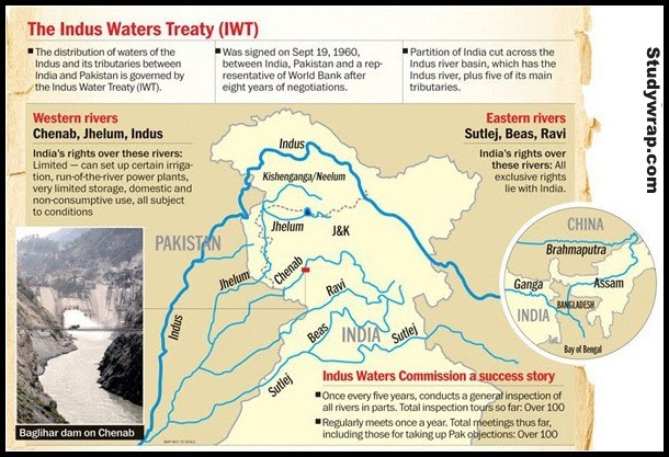
Indus Water Treaty

- Between India and Pakistan.
- Water of Indus River and its tributaries is shared between India and Pakistan.
- It was signed between both countries on 19th September, 1960.
- According to this treaty, India can utilize only 20% of its total discharge.
- According to this treaty the water of the Ravi, the Beas and the Satluj shall be available for the unrestricted use by India. India has also been permitted to make domestic use, non-consumptive use, uses for runoff the river Hydroelectric plants and specified agricultural use from the Indus, the Jhelum and the Chenab.
So, this was all about the Indus River System.
In the next post (Click here), we will start about the Ganga-Brahmaputra River System.
