Himalayan Drainage System – Ganga Brahmaputra River
Himalayan Drainage System
Table of Contents
- It consists of river originating in the Himalayas and Trans Himalayan region. It further consists of three river systems namely –
-
-
-
- Ganga
- Brahmaputra
- Indus
-
-
-
Ganga River System
“The Ganga Above all, is the river of India which has held India’s heart captive and drawn uncounted millions to her banks since the dawn of history. The story of the Ganga from her source to the sea, from old times to new, is the story of India’s civilization and culture.”
– Jawaharlal Nehru (Discovery of India)
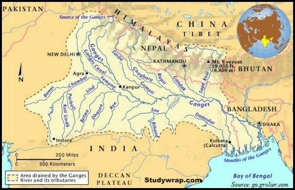
- The Ganga River system is the largest in India having number of perennial and non-perennial rivers originating in Himalaya in north and the peninsular plateau in the south respectively.
- It accounts for about 27% of geographical area of the country and a shared by 10 state.
- Ambala is located on the water divide between Indus and Ganga.
Major River Of Ganga River System
|
Tributaries |
Source |
|
Bhagirathi (Ganga) |
Gangotri glacier |
|
Yamuna |
Yamunotri glacier on Banderpunch peak |
|
Chambal |
Janapav Hills in vindhya range |
|
Banas |
Aravalli range |
|
Betwa |
Bhopal district |
|
Ken |
Barner range |
|
Son |
Amarkantak plateau |
|
Damodar |
Chota Nagpur Plateau |
|
Rāmgangā |
Garhwal district of Uttarakhand |
|
Ghaghra |
Gurla Mandhota peak, south of Mansarovar in Tibet |
|
Kali |
Glaciers of Trans Himalaya |
|
Gandak |
Tibet Nepal border |
|
Burhi Gandak |
Sumesar Hills near India Nepal |
|
Kosi |
Tumar, Arun and Sun Kosi unite at Triveni, north of the Mahabharat range to form the Kosi. |
The Ganga
Origin
-
-
- Originates at Gangotri glacier near Gaumukh in Uttar Kashi district as Bhagirathi in Uttarakhand at an elevation of 7010 m.
- Alaknanda River joins Bhagirathi at Dev Prayag.
- From Dev Prayag it is known as Ganga.
- Major tributaries of Alaknanda and Bhagirathi river
-
-
- Alaknanda
- East Trisul joins at Karan Prayag
- Pindar rises from Nanda Devi
- Mandakini or Kaliganga joins at Rudra Prayag
- Dhauliganga
- Bishenganga
- Bhagirathi
- Bheling
- Alaknanda
-
- Total length of Ganga River from its source to its mouth is 2525 km.
-
-
River Course
-
-
- Ganga enters from hills into plains at Haridwar.
- From here, it flows in in south and southeast direction for about 770 km to reach Prayagraj. Here it is joined by Yamuna at Triveni Sangam.
- From there it covers a distance of about 300 km to reach Bihar plains
- Near Rajmahal hills it turns to south east.
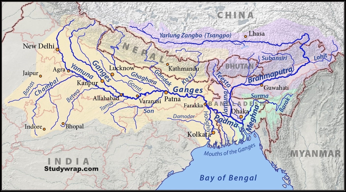
- At Farakka, it bifurcates into Bhagirathi-Hugli in West Bengal and Padma-Meghna in Bangladesh. (It ceases to be known as Ganga after Farraka).
- Brahamputra known as Jamuna in Bangladesh joins Meghna-Padma there.
- The river finally discharge itself into Bay of Bengal near Sagar Island.
-
Ganga Brahamputra Delta
-
-
- Before entering Bay of Bengal the Ganga-Brahamputra forms the largest delta of the world between Bhagirathi-Hugli and Padma-Meghna covering an area of 58752 sq. Km.
- The coastline of delta is highly indented area.
- The delta is made up of web of distributaries and islands are covered of dense forests.
- A major part of Delta is low lying swamp which is flooded by marine water during high tides.
-
Tributaries of Ganga River System
-
-
- Right bank tributaries
- Son, Yamuna
- Right bank tributaries
-
-
-
- Left Bank tributaries
- Ramganga, Gomati, Ghaghra, Gandak, Kosi, Mahananda
- Left Bank tributaries
-
Tributaries of Ganga River System (Right Bank)
|
Tributaries of Ganga River (Right Bank) |
||||
|
Tributary |
Origin and course |
Significance |
|
|
|
1.
|
Yamuna
|
Tributaries of Yamuna – Non Peninsular
Peninsular
|
|
|
|
|
Tributaries of Yamuna |
|||
Tons |
|
|
|
|
|
Chambal
|
Dams on Chambal Gandhi Sagar dam – first of four dams, located on Rajasthan – Madhya Pradesh border.
Rana Pratap Sagar Dam – located 52 km downstream of Gandhi Sagar dam on across the Chambal River near Chittorgarh district in Rajasthan.
Jawahar Sagar Dam – located 29 km upstream of Kota city and 26 km downstream of Rana Pratap Sagar dam.
The Kota Barrage – fourth in series, located about 0.8 km upstream of Kota district.
Water released after power generation at Gandhi Sagar dam, Rana Pratap Sagar dam, Jawahar Sagar dam is diverted by Kota barrage for irrigation in Rajasthan and Madhya Pradesh by canals.
|
|
|
|
Banas |
|
|
|
|
Sind |
|
|
|
|
Betwa |
|
|
|
|
Ken |
|
|
|
|
|
2. |
Son |
|
|
|
|
3.
|
Damodar |
|
|
|
Tributaries of Ganga River System (Left Bank)
|
Tributaries of Ganga River (Left Bank) |
|||
|
Tributary |
Origin and course |
Significance |
|
|
1. |
Ramganga |
|
|
|
2. |
Ghaghra |
|
|
|
3. |
Kali |
|
|
|
4.
|
Gandak |
|
|
|
5. |
Burhi Gandak |
|
|
|
6.
|
Kosi
|
|
|
|
7.
|
Sarda or Saryu |
|
|
|
8.
|
Mahananda |
|
|
Brahamputra River System
- Brahamputra (meaning – the Son of Brahama)
- Total length 2500 km
Origin
-
-
- Originates in Chemayungdung Glacier of the Kailash range near Mansarovar Lake. Mariam La separates the source of Brahamputra with the Mansarovar Lake.
- Its source is very close to the source of Indus and Satluj.
-
River Course
-
-
- Most of river course lies in Tibet. In Tibet it flows eastward in Southern Tibet for about 1800 km.
- It passes through the depression formed by the Indus-Tsangpo structure zone between Greater Himalaya and Kailash range in South and north respectively.
- The Tsangpo has gentle slope inspite of high altitude. The river is sluggish and has a wide navigable channel for about 640 km.
- Receives large number of tributaries in Tibet. First major tributary is the Raga Tsangpo meeting in Tsangpo near Latse Dzong.
- The river Ngangchu flows through the trade centre of Gyantse in South and joins the main river.
- Towards the end of its journey in Tibet, its course abruptly takes a south ward turns around Namcha Barwa (7756 m) (syntaxial bend).
- Here, it cuts across the eastern Himalaya through the Dihang or Siang Gorge and emerges from the mountains near Sadiya in Assam Valley.
-
-
-
- Here it flows with the name of Siong and then as Dihang.
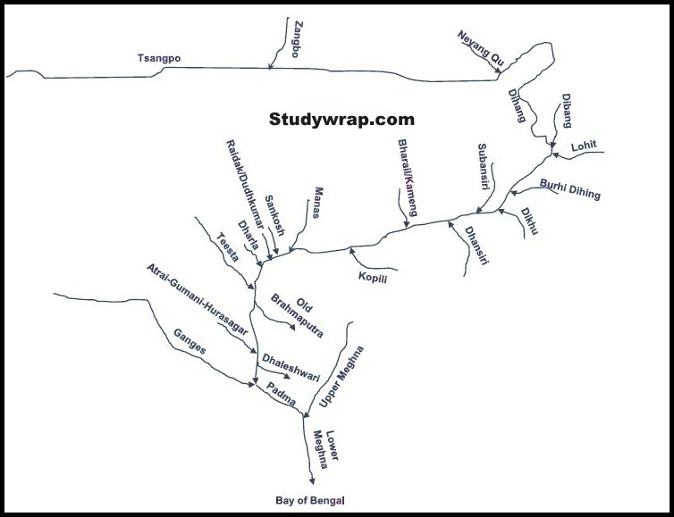
- In north eastern part of Assam valley it is joined by two important tributaries – Dihang from the north and Lohit from the south.
- From Sadiya (Assam valley) onwards, this mighty river is known as Brahmaputra.
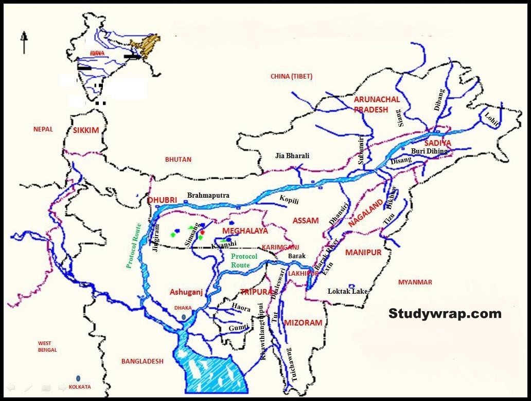
- The main stream merging with the Brahmaputra from the north are Subansiri, Kameg, Dhansiri, Raidak, Tista etc.
- The Tista was tributary of Ganga prior to flood of 1787 afterwards it diverted its course eastwards to joins Brahmaputra.
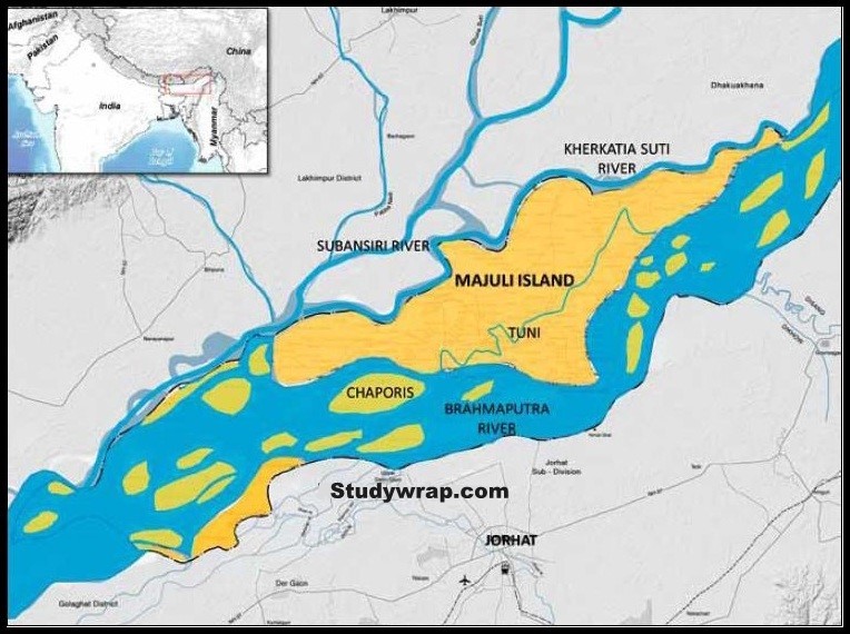
- The Brahmaputra has braided channels (flows into shallow interconnected channels divided by deposited earth) for most of its passage through Assam, where channels keep shifting. It carries lot of slit and hence excessive meandering happens.
- The river is nearly 16 km wide at Dibrugarh and forms many islands, the most important of which MANJULI. It is 90 km long and 20 km wide at its widest.
-
-
-
- With rainfall concentrated during monsoon month only the river has to carry enormous quantity of water and silt which result in disastrous flood. Thus, Brahmaputra is truly river of Sorrow.
- The river is navigable for a distance of 1384 km upto Dibrugarh from its mouth and serves as an excellent inland water transport route.
- It bends southwards and enters Bangladesh near Dhubri.
- It flows for a distance of 270 km in the name of Jamuna river and joins Ganga at Goalundo and afterwards known as Padma.
- Further downstream it is joined by Meghna on left bank originating from mountainous region of Assam.
- From the confluence of Meghna and Padma, the combined river is known as Meghna which makes a very broad estuaries before pouring into Bay of Bengal.
-
Other Names of Brahmaputra
-
-
- Tibet – Tsangpo
- China – Yarlung, Zangbo, Jiangin
- Assam – Dihang or Siang, south of Sadiya as Brahmaputra
- Bangladesh – Jamuna river
-
Padma River – combined water of Ganga and Brahmaputra
Meghna River – from the confluence of Padma and Meghna
Tributaries of Brahmaputra
-
-
- Left Bank Tributaries
-
Burhi Dihang, Dhansiri, Kalang
-
-
- Right Bank Tributaries
-
Subansiri, Kameng, Manas, Sankosh
That’s all about Ganga-Brahamputra River System.
In the next post (Click here), we would study in detail about West Flowing Peninsular Rivers.

Wow..Just searching for this only
Thanks