
Geography
The Indian Climate – The Monsoon Season of India (Rainy)
Indian Climate – Seasons
Table of Contents
-
-
- The cold weather season or winter season,
- The hot weather season or summer season,
- The south-west monsoon season of India or Rainy season, and
- The season of the retreating monsoon or cool season.
-

Rainy Season – South West Monsoon Season of India
- Monsoon Season of India starts with the onset of South West Monsoon Season – June to mid-September.
- South West Monsoon Season is also known as hot-wet season or The Wet Season.
- Sudden onset is the important feature of South West Monsoons.
- Chief Characteristics includes – High Heat, High Humidity, Extensive clouding and several spells of moderate to heavy rainfall with strong surface winds.
1. Temperature in Monsoon Season of India
-
- Significant fall in temperature with sudden onset of monsoon (3° to 6°C).
- The temperature remains uniform throughout the rainy season.
- There is rise in temperature whenever there is break in the monsoons.
- The temperature rises again in September with the conclusion of south-west monsoons.
- The diurnal range of temperature is small due to clouds and rains (ranges between 4oC to 8oC).
- The highest temperatures are experienced at places west of the Aravalli (38° to 40°C). This is due to lack of clouds and dominance of hot continental air masses.
- Other parts of Northwest India also have temperatures above 30°C.
- The temperatures are quite low over the Western Ghats due to heavy rainfall as compared to Rain-shadow area which is comparatively warmer due to low or scanty rainfall.
- The coastal areas of Tamil Nadu and adjoining parts of Andhra Pradesh have temperatures above 30°C as they receive little rainfall during this season.
2. Pressure and Winds in Monsoon Season of India

-
- Low pressure conditions still prevail over northwest India due to high temperature.
- Because of the heating of the subcontinent, by the middle of July, the low-pressure belt near the surface (termed as Inter Tropical Convergence Zone (ITCZ)) shifts northwards, roughly parallel to the Himalayas between 20° N and 25° N. The ITCZ in this position is sometimes called the monsoon trough.
- Roughly, this elongated low-pressure monsoon trough extends over the Thar Desert in the north-west to Patna and Chhotanagpur plateau in the east-southeast.
- ITCZ (monsoon trough) lies along the Ganga plain. There are frequent changes in its location depending upon the weather conditions.
- Meanwhile, the sea surrounding India heats up slowly, creating a zone of relatively high pressure off India’s Southern Coastline.
- Due to pressure gradient between north and south, warm moisture-laden air starts moving in south-westerly direction from Arabian Sea and Bay of Bengal over to India in the north and North East and is deflected by the Coriolis force as the Earth spins. It is this moist air current which is popularly known as the south-west monsoon.
- Their direction undergoes a change in Indo-Gangetic plain where they move from east to west.
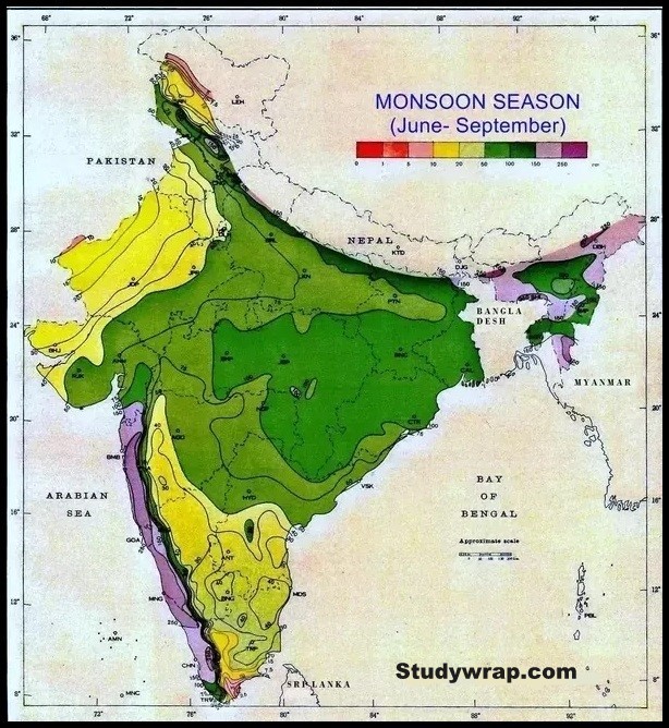
3. Rainfall in Monsoon Season of India
-
- Three fourths of the total annual rainfall is received during this season.
- The average rainfall over the plains of India in this season is about 87 per cent.
- The advance of the monsoon is much faster in the Bay of Bengal than in the Arabian Sea.
- Normal date of arrival of monsoon in Andaman and Nicobar Island is 20 May.
- The normal date of onset of the southwest monsoon over Kerala i.e. the first place of entry in the mainland of India is 1st June.
- The monsoons advance quickly complemented with a lot of thunder, lightning and heavy downpour. This sudden onset of rain is termed as monsoon burst.
- Sometimes monsoons are delayed or they come much earlier than normal. Normally the onset occurs between 29th May and 7th June.
- The earliest onset was on 11th May in 1918 and 1955, while the most delayed onset was on 18th June in 1972.
South West Monsoon – Arabian Sea Branch & Bay of Bengal Branch
-
- Monsoon winds beyond south Kerala progress in the form of two branches viz. the Arabian Sea branch and the Bay of Bengal branch.
- The Arabian Sea branch gradually advances northwards. It reaches Mumbai by 10th June.
- The Bay of Bengal branch spreads rather rapidly over most of Assam. The normal date of its arrival at Kolkata is 7th June.
- On reaching the foothills of the Himalayas the Bay branch is deflected westward by the Himalayan barrier and it advances up the Gangetic plain.
- The two branches merge with each other mostly around Agra to Ferozepur to form a single current.
- Both the branches reach Delhi more or less at the same time.
- The combined current gradually extends to west Uttar Pradesh, Haryana, Punjab, Rajasthan and finally to Himachal Pradesh and Kashmir.
- By the end of June the monsoon is usually established over most parts of the country.
- By mid-July, the monsoon extends into Kashmir and the remaining parts of the country.
- By the time it reaches Kashmir, it has shed most of its moisture and reaches there as only a feeble current.
a. The Arabian Sea Branch
-
- The Arabian Sea branch of the southwest monsoons is divided into three distinct streams on arriving in the mainland of India.
-
-
- One branch is obstructed by the Western Ghats. It strike perpendicular to Western Ghats causing plentiful Orographic Rainfall.
-
-
-
-
- As these winds climb the slopes of the Western Ghats, they become cooler, their moisture retention capacity reduces and as a result, the windward side of the Sahyadris and Western Coastal Plain receive very heavy rainfall ranging between 250 cm and 400 cm.
- Much of the rainfall along the Western Ghats is thus orographic, as the moist air is obstructed and forced to rise along the Ghats.
- Rainfall is drastically reduced to about 30-50 cm on the leeward side of the crest.
- After crossing the Western Ghats, these winds descend and get heated up. This reduces humidity in the winds. As a result, these winds cause little rainfall east of the Western Ghats. This region of low rainfall is known as the rain-shadow area.
- There is a narrow belt of marked aridity on the immediate leeward side of the Western Ghats. But once it is passed, the air starts rising again and the amount of rainfall increases further east.
-
-

-
-
- Another branch of the Arabian Sea monsoon strikes the coast north of Mumbai. Moving along the Narmada and Tapi river valleys, these winds reaches central India and cause rainfall. It does not cause much rain near the coast due to the absence of major orographic obstacle across the rift. The Chhotanagpur plateau gets 15 cm rainfall from this part of the branch. Thereafter, they enter the Ganga plains and mingle with the Bay of Bengal branch.
- The third branch of this monsoon wind strikes the Saurashtra Peninsula and the Kachchh. It then passes over west Rajasthan and along the Aravalli’s, causing only a scanty rainfall. Consequently the whole of Rajasthan is a desert area. However, some orographic effect is occurs on the south-eastern edge of the Aravalli Range. Mt. Abu gets about 170 cm rainfall while the surrounding plains have only 60 to 80 cm rainfall. In Punjab and Haryana, it too joins the Bay of Bengal branch. These two branches, reinforced by each other, cause rains in the western Himalayas.
-
Though this branch passes through Rajasthan, it does not cause rainfall there. This is because:
-
-
-
-
- The direction of Aravalli is parallel to these monsoon winds.
- The dry and hot winds from the Sindh region of Pakistan lessen the relative humidity of these monsoon winds and do not allow them to get saturated.
-
-
-
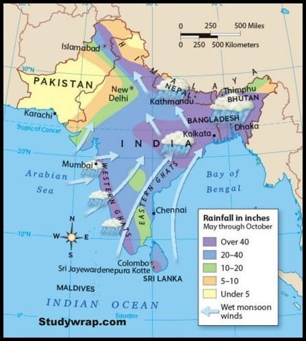
b. The Bay of Bengal Branch
-
- The Bay of Bengal branch strikes the coast of Myanmar and parts of south-east Bangladesh. But the Arakan Hills along the coast of Myanmar deflect a big portion of this branch towards the Indian subcontinent.
- The monsoon, therefore, enters West Bengal and Bangladesh from the south and south-east instead of from the south-westerly direction.
- Due to Himalayas and low pressure in north western India, The Bay of Bengal branch of the southwest monsoon is divided into two distinct streams–
-
-
- The first stream crosses the Ganga-Brahmaputra delta moves up the Brahmaputra valley in the north and the northeast and reaches Meghalaya, causing widespread rains.
-
-
-
- Here that the orographic effect results in intense rainfall. Cherrapunji receives an annual rainfall of 1,102 cm, major portion of which occurs from June to August.
- Mawsynram located at 1,329 m above sea level just 16 km to the west of Cherrapunji records higher annual rainfall of 1,221 cm.
- Both the stations are located on the southern slopes of the Khasi hills at the northern end of a deep valley running from south to north.
- Heavy rainfall is due to the fact that when monsoon winds blow from south they are trapped within the funnel shaped valley and strikes the Cherrapunji and Mawsynram in a perpendicular direction. There is relatively less rainfall on the leeward slope of the Meghalaya Plateau e.g. 143 cm in Shillong and 161 cm in Guwahati which is very less in comparison to that in Mawsynram.
-
-
-
- The second stream of the Bay of Bengal branch moves along Himalayan foothills as they are deflected to the west by the Himalaya and brings widespread rainfall to Ganga plain reaching as far as the Punjab plains.
-
-
-
- The rainfall by this stream is characterized by a steady decline as we move from east to west up the plain.
- In the Gangetic Plains, the two branches merge into one (Bay of Bengal Branch + Arabian Sea Branch). By the time they reach the Punjab their moisture is largely spent. The gradual reduction in the amount of rainfall toward the west is evidenced by the decline from 162 cm at Kolkata to 66 cm at Delhi and to desert conditions still farther west.
-
The Tamil Nadu coast remains dry during this season, it is because –
-
-
- The Tamil Nadu coast remains relatively dry during the south-west monsoon period because of
- rain shadow effect of the Arabian Sea current and
- Bay of Bengal current which flows parallel to the coast.
-
Arabian Sea branch of the monsoon is much powerful than the Bay of Bengal branch because –
-
-
- The Arabian Sea is larger than the Bay of Bengal, and
- The entire Arabian Sea current advances towards India, whereas only a part of the Bay of Bengal current enters India, the remainder proceeding to Myanmar, Thailand and Malaysia.
- The Arabian Sea branch is stronger than the Bay of Bengal branch. 65% of the humidity brought by the monsoon comes from the Arabian Sea whereas the monsoon coming from the Bay of Bengal contributes only 35% to the humidity.
-

Break in the South West Monsoons
-
-
- During the south-west monsoon period after having rains for a few days, if rain fails to occur for one or more weeks, it is known as ‘break’ in the monsoon. These dry spells are quite common during the rainy season.
- During July and August, there are certain periods when the monsoons become weak. Rainfall practically ceases over the country outside the Himalayan belt and southeast peninsula. This is known as break in the monsoon.
- Breaks are likely to occur during the second week of August and last for a week.
- The breaks are believed to be brought about by the northward shifting of the monsoon trough (minimum low pressure cell in ITCZ). The axis of the trough lies at the foothills of the Himalayas during the break period.
- During the break period, heavy rainfall occurs over the sub-Himalayan regions and the southern slopes of the Himalayas.
-
Reasons:
-
-
- In northern India rains are likely to fail if the rain-bearing storms are not very frequent along the monsoon trough or the ITCZ over this region.
- Over the west coast, the dry spells are associated with days when winds blow parallel to the coast.
-
Depressions in South West Monsoon Season
-
-
- A major part of the South West Monsoon rainfall is generated by originating in the Arabian Sea and Bay of Bengal. Some depressions develop over land also.
- About 3-4 depressions are formed per month from June to September.
- Almost all of them are sucked inward through the deltas of great rivers the Ganga, the Mahanadi, the Godavari, the Krishna and the Cauvery and cause heavy rain in these areas.
- The location of depressions strongly coincide with the latitudinal position of ITCZ.
- In June, Most of the depression originate to the west of 90⁰ E in Bay of Bengal and move in north-west direction.
- In the Arabian Sea in June-July, the depressions move either in north-west or in northerly direction and may affect west Gujarat or Maharashtra.
- Storms during August and September are rare and are formed close to Maharashtra-Gujarat coast.
- Most of the rainfall in central and northern parts of the country is caused by these depressions.
- The absence of depressions or a change in their tracks result in deficit or no rain.
-
Chief Characteristics of South West Monsoon Rainfall
-
- Major part of monsoon rains are received between June and September Hence, rainfall is seasonal in character.
- Monsoonal rainfall is largely governed by relief and is orographic in its mode.
- The amount of rainfall decreases with increasing distance from the sea.
- The monsoon rains occur in wet spells of few days interspersed with rainless interval known as ‘breaks’. The breaks in rainfall are related to tropical cyclones which originate in the Bay of Bengal.
- Heavy Rainfall by the southwest monsoon results in large scale run-off and soil erosion.
- There are large scale spatial variations in the distribution of rainfall which varies from 12 cm to 250 cm.
- Monsoons often fail to keep date. Sometimes the monsoons withdraw before the scheduled time causing considerable damage to the crops.
- Sometimes monsoon withdraw before the scheduled time causing considerable damage to the crops.
So, this was all about the Climate of India in Rainy or Monsoon Season of India.
In the next post (Click here), we will study about The Cool Season or Autumn Season in India.
