
Major Mountain Passes in India
Major Mountain Passes in India
Table of Contents
What are Mountain Passes?
- A Mountain Pass is a narrow route that connects two mountain ranges. A mountain pass is formed when land between areas of higher terrain is eroded by a glacier or stream. Mountain pass is a connectivity route through the mountain ranges.
- Mountain passes between mountain peaks may form during the formation of the mountain range, or they may form as a result of the action of glaciers, running water, or precipitation in the form of rain or snow.
- It’s known as a hill pass at lower elevations.
- They can range in size from small, steep peaks to vast valleys that stretch for miles.
- Passes are frequently located near the source of a river fed by precipitation and snowmelt.
- India is a land of numerous passes. In Tibet, it is known as ‘La,’ which means ‘pass.’
Significance of Mountain Passes
-
- Passes are frequently the most convenient way for people to travel across steep mountain ranges.
- They have played an important role in human migration, trade, and settlement throughout history.
- As they are often usually the only flat land in a mountainous area, passes are good places to build settlements or defensive outposts.
- In some parts of the world, passes serve as a link between cultures that are separated by mountains.
- They serve as a vital trade route between countries.
Mountain Passes in India
-
- Mountain Passes are found in Jammu and Kashmir, Ladakh, Himachal Pradesh, Uttrakhand, and the north-eastern states of India, and are collectively referred to as Himalayan Passes.
- Mountain passes are prominently located in Maharashtra, Kerala, and Tamil Nadu in the Western Ghats due to the continuous nature of mountain ranges.
- Most of the passes remain closed in winter (Nov – Apr) due to heavy snow fall.
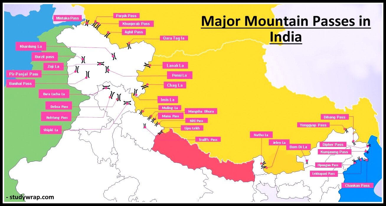
State-wise List of Mountain Passes of India– Location & Significance
Major Mountain Passes in Leh-Ladakh
|
Major Passes in Leh-Ladakh |
||
|
Chang La |
Ladakh with Tibet |
From Leh, Chang La allows access to Pangong Lake. Height – 5360 m, it is one of the highest motorable passes. This has a temple dedicated to Chang-La Baba after whom the temple has been named. Because of the low oxygen level, it is not recommended that you spend too much time there. |
|
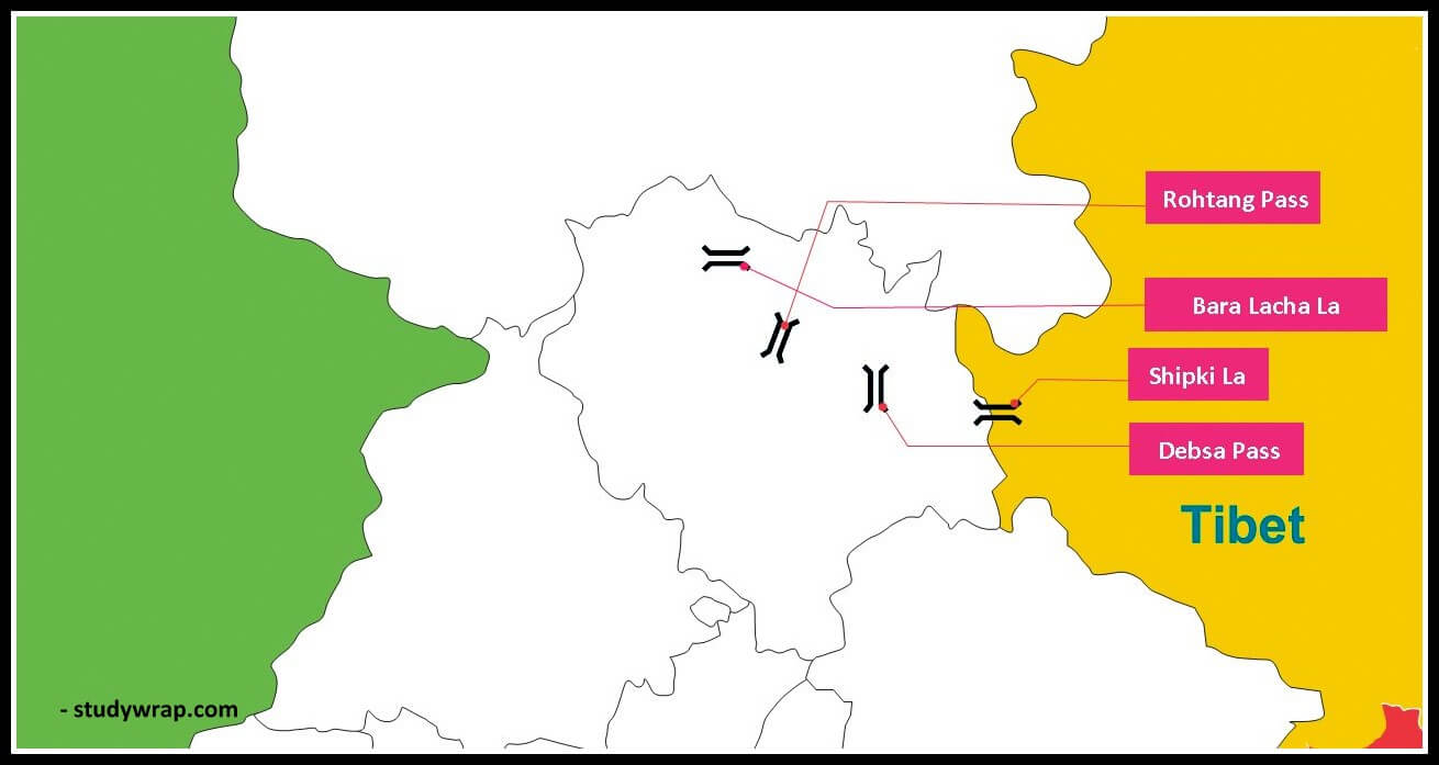
Bara-Lacha La Pass |
connects Lahual and Ladakh |
This pass, located in the Himalayan Zanskar Range, connects Lahual and Ladakh and is known as the “Gateway to Ladakh.” This lovely destination has always been a historical landmark, serving as an important trade route in the past. |
|
Khardung La |
near Leh in the Ladakh range |
Height – 5602 m Khardung La is a mountain range in Tibet. It acts as a passageway to valleys such as Nubra Valley. It plays a critical role in the transportation of supplies to the Siachen Glacier. One of the world’s highest motorable road passes through this pass. It remains closed in winter due to heavy snowfall. |
|
Imis La |
Ladakh region of India and Tibet in China |
This is where the Hanle Valley, which is historically significant in terms of Buddhism, began. |
|
Zoji La Pass |
important road link between Srinagar on one side and Kargil and Leh on the other side |
This pass, which is located in Dras, connects three regions – Kashmir Valley in West Indus Valley in East Suru Valley in North-East Due to heavy snowfall, work on the Zoji La Tunnel began in 2020, which will make transportation even easier. The road passing through this pass has been designated as the National Highway (NH-1D) Border Road Organisation (BRO) is responsible for maintaining the road and cleaning it off snow during winter. In spite of all these efforts, the road through this pass remains closed from December to mid-May. |
|
Tanglang La Pass |
|
Tanglang La Pass, at an elevation of 5,328 m is one of Ladakh’s most spectacular high altitude mountain passes. This high altitude mountain pass in Ladakh is about 49 kilometres long and is located on the way from Debring to Gya. |
|
Aghil Pass |
Ladakh region of India with the Xinjiang Province of China |
Height – 5000 m. north of K2 Peak (the highest peak in India and the second highest peak in the world) |
|
Lanak La |
India and China (Akasai-Chin area) |
This pass provides passage between Ladakh and Lhasa. A road to connect Xinjiang Province with Tibet has been constructed by the Chinese. |

Major Passes in Jammu and Kashmir
|
Major Passes in Jammu and Kashmir |
||
|
Karakoram Pass |
|
It connects India and China and is located in the Karakoram Mountain region. By allowing travellers to cross these mountain ranges, it played a significant historical role. This pass is quite unpredictable due to its barren and uneven terrain. |
|
Pir Panjal Pass |
across the Pir Panjal range |
Peer ki Gali serves as a link between the districts of Kashmir Valley and Rajouri. It provides the shortest and the easiest metal road between Jammu and Kashmir Valley. Mughal Road passes through this pass. It serves as a vital connection between India and Pakistan. |
|
Banihal Pass |
Jammu and Srinigar |
Height – 2832 m Located across the Pir-Panjal Range, remains snow covered during winter season. This mountain pass was crossed by a trail from Jammu to Srinagar in 1956, and Jawahar Tunnel was located beneath it. The road now passes through the tunnel and the Banihal Pass is no longer used for road transport. Another 11 km long tunnel provides railway link between Banihal and Kazigund. It was open to railway transport in July, 2013. Near Banihal Pass is the Zaban Glacier. |
|
Burzail Pass |
|
This pass connects Kashmir’s Astore Valley and Ladakh’s Deosai Plains. |
|
Pensi La |
vital link between the Kashmir Valley and Kargil |
The Pensi La is a pass that connects Kashmir and Kargil. It is found in the Greater Himalayan range. It remains closed to traffic from November to mid-May due to heavy snowfall. |
|
Qara Tag La |
Indo-China border across the Karakoram Range |
located at an elevation of over 6000 m |
|
Mintaka Pass |
Kashmir and China |
Trijunction of India-China and Afghanistan border |
|
Parpik Pass |
Kashmir and China |
East of Mintaka pass on the Indo-China border |
|
Khunjerab Pass |
Kashmir and China |
Indo-China border |
Major Mountain Passes in Himachal Pradesh
|
Major Passes in Himachal Pradesh |
||
|
Shipki La |
Himachal Pradesh and Tibet |
Height – 6000 m Remains closed in winter season (Nov – Apr) It connects the districts of Kinnaur and Tibet. This pass is not accessible to non-residents. It’s mostly used for short-distance trade between India and Tibet. |
|
Rohtang Pass |
road link between Kullu, Lahul and Spiti Valleys |
Height – 3979 m It is a dividing point, with one side leading to Kullu Valley and the other to Lahaul-Spiti. Border Road Organisation (BRO) is responsible for constructing and maintaining roads in this area. Rohtang pass is a great tourist attraction and traffic jams are very common because this route is widely used by military, public and private vehicles. Due to the short opening window, which is usually from May to October, it is one of the most congested passes. |
|
Bara-Lacha La |
Himachal Pradesh and Jammu and Kashmir |
Height – 4,890 m It connects Lahaul and Leh by crossing the Zaskar range. On the Manali side of the pass, the Bhaga river is one of the Chenab river’s tributaries. National highway connecting Mandi in Himachal Pradesh with Leh in Jammu and Kashmir passes through this pass. Being situated at high altitude, it remains snow covered in winter and is not used as a transport route. |
|
Debsa Pass |
link between Kullu and Spiti districts |
Height – 5270 m This pass was discovered in 1995 by a group of mountaineers led by Joydeep Sircar. It offers a much easier and shorter alternative route to traditional Pin-Parbati Pass route between Kullu and Spiti. |
Major Mountain Passes in Uttarakhand
|
Major Passes in Uttarakhand |
||
|
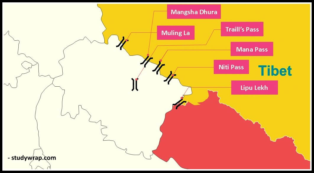
Lipu Lekh Pass |
trijunction of Uttarakhand (India), Tibet (China) and Nepal borders |
It was India’s first border post to allow trade with China. This pass is used by pilgrims to Kailash-Mansarovar. |
|
Mana Pass |
Uttarakhand with Tibet |
Height – 5610 m It connects the Mana district of Uttarakhand with Tibet. The Nanda Devi Biosphere Reserve encompasses this pass. Situated a little north of the holy place of Badrinath Remains closed in winter season (Nov – Apr) |
|
Niti Pass |
Uttarakhand with Tibet |
It was once a vital link between Tibet and the rest of the world, but it has been closed since 1962. Remains closed in winter season (Nov – Apr) |
|
Mangsha Dhura |
Uttarakhand with Tibet |
It is also important in the Mansarovar Yatra. |
|
Muling La |
Uttarakhand and Tibet |
Height – 5669 m It is located in the Great Himalayas, north of Gangotri. During the winter, this pass is snow-covered. |
|
Traill’s Pass |
|
It connects the Pindari and Milam valleys and is located at the end of the Pindari glacier. This pass is extremely rugged and steep. |
Major Mountain Passes in India – North Eastern States
Major Passes in Sikkim

|
Major Passes in Sikkim |
||
|
Nathu La |
Sikkim with Tibet |
Height – 4310 m It forms part of an offshoot of the ancient Silk Route. An important trade route between India and China. It was closed after the Chinese aggression on India in 1962 but was reopened in 2006 as the governments of the two countries decided to enhance their trade through land routes To visit this pass, Indian citizens must first obtain a permit. |
|
Jelep La |
Sikkim-Bhutan border |
Height – 4538 m passes through Chumbi Valley important link between Sikkim and Lhasa. Since the Sino-Indian War in 1962, it has been closed to the public. |
Major Passes in Arunachal Pradesh
|
Major Passes in Arunachal Pradesh |
||
|
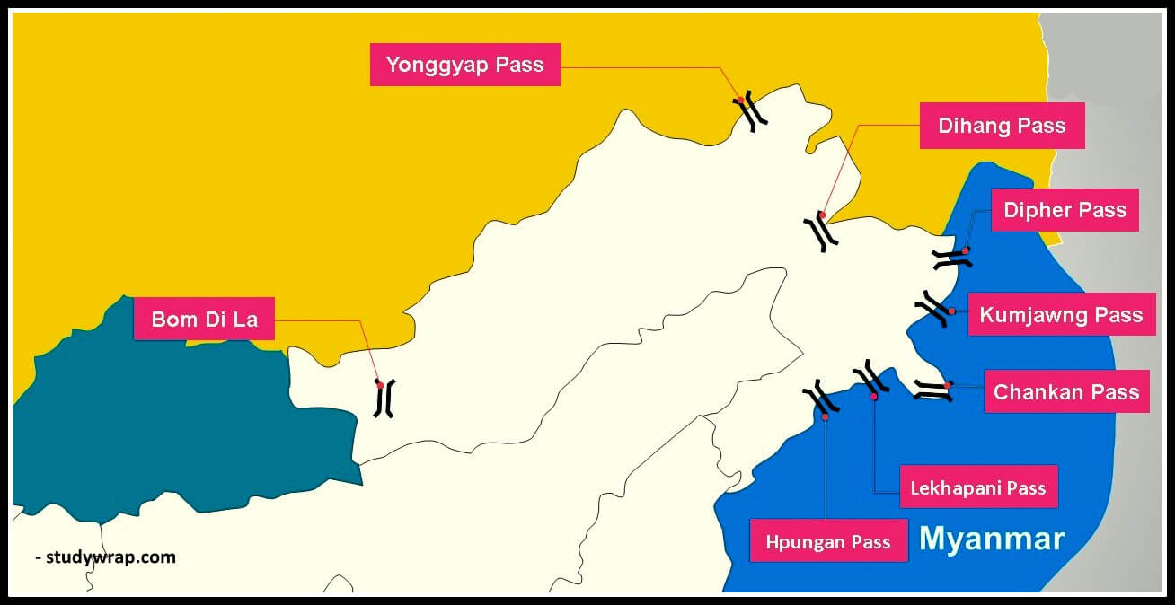
Bom Di La |
Arunachal Pradesh with Bhutan |
Height – 4331 m It connects Arunachal Pradesh with Tibet, specifically the city of Lhasa. |
|
Dihang La |
Arunachal Pradesh and Myanmar. |
Height – above 4000 m This pass connects the states of Arunachal Pradesh and Myanmar in the north-east. |
|
Diphu Pass (Dipher Pass) |
trijunction of India, China and Myanmar |
Located on the McMohan Line, which serves as a dividing line between Tibet and India’s north-east. Easy access between Arunachal Pradesh and Mandalay in Myanmar. It is an important land trade route between India and Myanmar and remains open throughout the year. |
|
Pangsau Pass (Pan Saung Pass) |
Arunachal Pradesh and Myanmar |
Height – 1,136 m It is located on the crest of the Patkai Hills on the India-Burma (Myanmar) border. From the Assam plains, the pass provides one of the most direct routes into Burma. It is named after the nearest Burmese village, Pangsau, which is located 2 kilometres east of the pass. |
|
Kumjawng Pass |
Arunachal Pradesh with Myanmar |
|
|
Hpungan Pass |
Arunachal Pradesh with Myanmar |
|
|
Chankan Pass |
Arunachal Pradesh with Myanmar |
|
Major Mountain Passes in India – Central India
|
Major Passes in Central India |
||
|
Asirgarh Pass |
Madhya Pradesh |
Located in the Satpura Range, Madhya Pradesh. Height – about 260 m. The Asirgarh Pass connects the Narmada and Tapti Valleys and is also known as the ‘Key to the Deccan’ for being among the most important routes from northern India to the Deccan. |
|
Goram Ghat |
Rajasthan |
Located in the Aravali Range in Rajasthan. It connects Mewar and Marwar in Rajasthan through the Aravali Hills and has a railway line passing through it. The terrain is densely forested with Dhok forest and is rich in biodiversity. |
|
Haldighati Pass |
Rajasthan |
Located in the Aravali Range in Rajasthan. The name Haldighati is derived from the turmeric colored soil in the mountain pass. Located about 40 km from Udaipur, the mountain pass is said to be the historic location of the ‘Battle of Haldighati’ between the Mewar king Maharana Pratap and the Mughals under Emperor Akbar in 1576. |
Major Mountain Passes in India – Western Ghats
|
Goa, Karnataka, and Maharashtra |
||
|
Bhor Ghat |
Maharashtra |
This pass is used to connect three different locations – Railway route between Palasdari and Khandala. Road route between Khopoli and Khandala |
|
Thal Ghat |
Maharashtra |
It can be found on Mumbai-Nashik Road. The railway line that runs through this pass is one of India’s steepest. In Maharashtra, it connects Kalyan and Kasara. |
|
Amba Ghat Pass |
Maharashtra |
It has picturesque mountain-scapes and a pleasant climate. This region is famous for paragliding sport Location – Sahyadri Mountains of Western Ghats |
|
Chorla Ghat Pass |
Maharashtra |
State – Goa, Karnataka, and Maharashtra. Location – Sahyadri mountain range of Western Ghats (On the intersection of the borders of Goa, Karnataka, and Maharashtra) |
|
Malshej Ghat Pass |
Maharashtra |
Location – Sahyadri Range of Western Ghats (Lofty rugged hills of the Western Ghats) |
|
Naneghat Pass |
Maharashtra |
It is also called as Nanaghat or Nana Ghat. It was a part of an ancient trading route. |
|
Tamil Nadu and Kerala |
||
|
Palakkad Ghat (Pal Ghat) |
Tamil Nadu and Kerala |
It connects the states of Tamil Nadu and Kerala. At an elevation of 460 feet, it’s a narrow chasm. The Pal Ghat passes through the Nilgiri Hills and the Anaimalai Hills. |
|
Shencottah Gap |
Tamil Nadu and Kerala |
The Western Ghats are home to it. It connects the Tamil Nadu city of Madurai with the Kerala district of Kottayam. Shencottah Gap, the second-largest gap in the Western Ghats, is located five kilometres from town and connects Shencottah and Punalur. Road-rail lines pass through this gap, which connects Shencottah and Punalur. |
So, this is all about the Major Mountain Passes in India. If you want to read more notes on Indian Geography – Click Here.
In the Next Post (Click Here), we will learn about the Major Mountain Ranges of India.
If you Like this Post than please share it with your friends and family and like our Facebook Page to get regular updates. Sharing is Caring J.
