Major Mountain Ranges of India
8 Major Mountain Ranges of India
Table of Contents
What is Mountain Range?
· A Mountain Range is a sequential chain or series of mountains or hills with similarity in form, structure, and alignment that have arisen from the same cause, usually an orogeny.
· A mountain range is a series of mountains stretched in a line and joined by high ground. Mountain ranges are usually segmented by highlands or mountain passes and valleys.
· India has some of the highest mountain ranges and mountain roads in the world. India is home to seven major mountain ranges that have peaks of over 1000 metres.
· The most famous and the highest mountain range of India is the Himalayan range. It is also the youngest and the longest mountain range in India and has almost every largest peak of the world.
Mountain Ranges of India
· India has some of the highest mountain ranges in the world.
· It also has some of the world’s highest mountain roads.
· The Great Himalayan mountain ranges are the famous and highest mountain hills of India.
· The Himalayan mountain range bisects India from the rest of Asia, this mountains is the primary source of mighty rivers in India.
· These mountain ranges in India are treasure troves of natural resources. They travel through the entire length and breadth of the Indian subcontinent. These are not just homes to the numerous flora and fauna but have also played a vital role in shaping the culture, tradition, and economy of the regions surrounding them.
Major Mountain Ranges of India
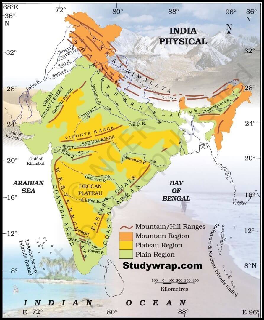
· Some of the Major Mountain Ranges of India are –
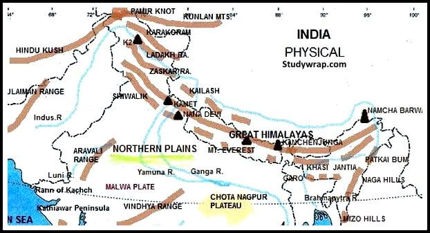
1. Himalayan Ranges
2. Trans Himalayan Ranges
3. Eastern Mountain Range/ Purvanchal Range
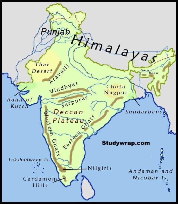
4. Satpura Ranges
5. Vindhyan Ranges
6. Aravalli Range
7. Western Ghats
8. Eastern Ghats

The Himalayan Range
Geography
· The Himalayas stretch across the north-eastern portion of India. They cover roughly 2,400 km and pass through the countries of India, Pakistan, Afghanistan, China, Bhutan, and Nepal. The Himalayan range is made up of three parallel ranges often referred to as the
o Greater Himalayas,
o The Lesser Himalayas, and
o The Outer Himalayas.
Great Himalayas/Inner Himalayas
o Highest peak – Mount Everest (Sagarmatha)
o This range is also called as Inner Himalayas. It is the north most range which also contains the highest peaks of world.
o This range is the source of many Himalayan rivers.
o It is about 25 Km wide and the average height of the mountains is 6000 m.
o Mount Everest which is the highest peak of the world (8848 m) comes in this range.
o The other important peaks of this range are Kanchenjunga (8598 m), Makalu (8481 m) and Dhailagiri (8172 m).
o Most of the rocks in this range are metamorphic.
Lesser Himalayas/Middle Himalayas/Himachal
o This mountain range comes to south of the Great Himalayas.
o Average height of the mountains is about 1800 m and the width varies from 80 to 100 Km.
o Himalayan rivers have cut deep gorges in this range.
Sub Himalayas/Outer Himalayas/Shivalik/Manak Parvat
o This is the third range southmost to Great Himalayas and Shivalik.
o The range is considered to be swept between Potwar Basin in west and Teesta river basin in east.
o The length of this basin is about 2500 Km.
Highest Peak
· Mount Everest at 29,029 ft (8,848 m) is not only the highest peak in the Himalayas but the highest peak on the entire planet. The highest peak that’s entirely in India is Nanda Devi in the Garhwal region of Uttarakhand, at 25,643 feet.
· Other famous peaks include Karakoram (K2), Kailash, Kanchenjunga, Nanga Parbat, Annapurna, and Manasklu.
Ecology
· The flora and fauna of the Himalayas vary with climate, rainfall, altitude, and soils. The climate ranges from tropical at the base of the mountains to permanent ice and snow at the highest elevations.
· Montane Grasslands and Shrublands, Temperate Coniferous Forest, Temperate Broadleaf and Mixed Forests, Tropical and Sub-tropical Broadleaf Forests.
Rivers
· The Himalayas are the source for the Indus, the Yangtze, and the Ganga-Brahmaputra. All three are major river systems for the continent of Asia.
· The main rivers sourced in the Himalayas are the Ganges, Indus, Yarlung, Yangtze, Yellow, Mekong, and Nujiang.
Glaciers
· The Himalayas are the third-largest deposit of ice and snow in the world, after Antarctica and the Arctic. There are approximately 15,000 glaciers located throughout the range. At 48 miles (72 km) in length, the Himalayan Siachen glacier is the largest glacier outside the poles.
· Other notable glaciers located in the Himalayas include the the Gangotri and Yamunotri (Uttarakhand) and Khumbu glaciers (Mount Everest region), Langtang glacier (Langtang region) and Zemu (Sikkim).
Passes
· Rohtang La, Khardung La, South Col, Zoji La, Nathu la etc.
Trans Himalayan Ranges/Minor ranges of Himalayan System
Hindu Kush Range
· Highest Peak – Tirich Mir (7,708 m)
· This is also known as Pariyatra Parvat.
· It is 800 Km long mountain range that starts from central Afghanistan up to Nothern Pakistan.
· The highest peak of this range is Tirich Mir (7690m) which comes in central district of Khyber Pakhtukhwa, Pakistan.
· This mountain range separates South Asia from Central Asia.
Karakoram Range
· Highest Peak – Mount K2 (Godwin Austen), (Height 8611 m)
· This is also a minor range of Himalayan system. It is situated across Pakistan, India and China located in the regions of Gilgit Baltistan (Pakistan), Ladakh (India) and Xinxiang (China).
· It is a subrange of Hindu Kush Mountain Range.
· This range has highest concentration of peaks above 8000 m. K2 (8611 m) is the highest peak of this range and second highest in whole world.
· This is spread in a length of 500 km and contains most heavy glaciers. Siachen glacier which has a length of 76 Km and Biafo glacier (63 Km) belongs to this range and are second and third longest glaciers outside polar region.
Zaskar Range
· Highest Peak – Reo Purgyil (Kinnaur, Himachal Pradesh) (Height – 6,816 m)
· It is a mountain range in Jammu and Kashmir which separates Kargil district from Ladakh.
· The average height of Zaskar range is 6000 m.
· The highest peaks of Himachal Pradesh lies on Zaskar range.
· It separates Kinnaur district from Spiti in Himachal Pradesh.
Pir Panjal Range
· Highest Peak – Indrasan
· It is the minor range of Inner Himalayas running from Pak occupied Kashmir to Jammu and Kashmir and then toward Himachal Pradesh.
· It runs from North West to South East direction.
· It forms a divide between rivers Chenab at one side and Ravi at other side.
· The famous hill station Gulmarg of Kashmir comes in this range.

The Purvanchal Range
Geography
· They extend in Arunachal Pradesh, Nagaland, Manipur, Mizoram, Tripura, and eastern Assam states.
· The range is an eastern extension of the Himalayan Range System, in north eastern India. It bends sharply to the south beyond the Dihang River gorge, and spreads along the eastern boundary of India with Myanmar.
· The Patkai and other associated mountain ranges (including the Mishmi, Naga, Manipur, Tripura, and Mizo hills) that run through this region are referred to collectively as Purvachal (Purva, “east,” and achal, “mountain”).
· The area is bounded by Bangladesh to the southwest, Myanmar (Burma) to the southeast, and China to the northeast.
Highest Peak
· The average height of peaks in this range is about 9,845 ft.
· The highest peak in the region is Mount Dapha in the Mishmi Hills, Arunachal Pradesh, with an elevation of 4,578 m (15,020 ft).
Vegetation
· The vegetation is diverse, ranging from tropical evergreen to temperate evergreen and coniferous, and includes species of oak, chestnut, birch, magnolia, cherry, maple, laurel, and fig. There are also extensive bamboo thickets.
Rivers
· The major rivers are the Lohit, Burhi Dihang, Diyung, Kusiyara, Gumti, Kaladan, Manipur, Tixu, Nantaleik, and Naurya.
The Vindhya Range
Geography
· The Vindhya Range runs across central India on the northern side of the Narmada River in Madhya Pradesh.
· It is broken range of hills forming the southern escarpment of the central upland of India.
· It extends about 1,086 km from Gujarat state on the west across Madhya Pradesh state to border on the Ganga River valley near Varanasi, Uttar Pradesh.
· The mountains form the southern edge of the Malwa Plateau and then divide into two branches – the Kaimur Range, running north of the Son River into Bihar, and the southern branch, running between the upper reaches of the Son and Narmada rivers to meet the Satpura Range in the Maikala Range (or Amarkantak Plateau).
Highest Peak
· The highest point of the Vindhyas is the Sadbhawna Shikhar (“Goodwill Peak”), which lies 752 m (2,467 ft).
· Also known as the Kalumar peak or Kalumbe peak, it lies near Singrampur in the Damoh district, in the area known as Panna hills.
Rivers
· It gives rise to the main southern tributaries of the Ganges-Yamuna system, including the Chambal, Betwa, Ken, Tamas, Parbati and Tons rivers.
Ecology
· The forests of the Vindhya highlands are of tropical dry deciduous forest type. They are characterized by large trees spread far apart, between shrubs and grasses. This gives the appearance as a savannah.
· They provide habitats for large mammal species, threatened species like Sloth bear, Tiger, Swamp Deer, Chousingha, Wild dog.
The Satpura Range
Geography
· On the southern side of the Narmada River in Madhya Pradesh, the Satpura Range runs parallel to the Vindhya Range in between the Namarda and Tapti rivers.
· It extends for about 900 km from the Rajpipla Hills in Gujarat to the Maikala Hills in Chhattisgarh where it meets the Vindhya Range at Amarkantak, running through the states of Gujarat, Maharashtra, Madhya Pradesh and Chhattisgarh.
Highest Peak
· The highest peak of the Satpura mountain range is Dhupgarh with a height of 1,350 m (4,429 ft) in Madhya Pradesh.
· With peaks more than 4,000 feet (1,200 metres) high, the Satpura Range includes the Mahadeo Hills to the north, the Maikala Range to the east, and the Rajpipla Hills to the west.
Rivers
· Satpura range is triangular with its apex at Ratnapuri other two sides being parallel to the Tapti and Sacred Narmada River.
· The Narmada and the Tapti are the only major rivers that flow into the Arabian Sea.
Ecology
· Several protected areas have been earmarked in the area, including the Kanha, Pench, Gugamal and Satpura National Parks, Pachmarhi Biosphere Reserve, Melghat Tiger Reserve and the Bori Reserve Forest.
Vegetation
· It is largely forested, dissected plateau and it contains valuable teak stands in the west.

The Aravalli Range
Geography
· Aravalli Range is hill system of northern India, running northeasterly for 670 km from Champaner and Palampur in eastern Gujarat to the outskirts of Delhi.
· About 80 percent of it is situated in Rajasthan, where it borders the Thar Desert and provides protection from the extreme desert climate.
· The Aravalli Range is considered the oldest fold mountain system in the world, having its origin in the Proterozoic Era.
· The Aravalli Range is the eroded stub of a range of ancient folded mountains.
Highest Peak
· Guru Peak at Mount Abu, the highest peak in the Aravalli Range near the Gujarat border, with an elevation of 1,722 m (5,650 ft).
· However, most of the hills are concentrated in the area around Udaipur.
Ecology
· The Aravalli is rich in biodiversity and provides habitat to a wide variety of endemic fauna and flora, especially leopards and striped hyenas. A number of national parks, wildlife reserves, and tiger reseves lie in the Aravalli Range.
· A number of national parks, wildlife reserves, and tiger reseves lie in the Aravalli Range. Some of the most prominent ones are the Sariska tiger reserve, Ranthambore national Park and Aravalli Biodiversity Park.
Vegetation
· The natural vegetation of the park falls within the Northern Tropical Dry Deciduous Forest and Northern Tropical Thorn Forest types.
Rivers
· It gives rise to several rivers, including the Banas, Chambal, Luni, Sakhi, and Sabarmati.
The Western Ghats
Geography
· The Western Ghats runs for roughly 1,600 km along the western side of India, separating the coast from the Deccan plains.
· It extends from near the Satpura Range in Gujarat down through Maharashtra, Goa, Karnataka, Kerala and Tamil Nadu to end at the southernmost tip of India near Kanyakumari. The Western Ghats is made up of multiple mountain ranges.
· It is sometimes called the Great Escarpment of India.
Ecology
· These mountains influence India’s weather by acting as a barrier against the southwest monsoon clouds and drawing much of the rainfall.
· The mountains are home to about 30 % of India’s flora and fauna and are recognized as a UNESCO World Heritage Site and one of the top biodiversity hot-spots in the world.
· The Arabian Sea area is known as the Konkan area, one of the best tourist attractions in India.
· Green city Pune is the largest city within this mountain range in Maharashtra.
· There are several beautiful hill stations and wildlife sanctuaries in Kerala.
Highest Peak
· AnaiMudi in the Anaimalai Hills in Kerala is the highest peak in the Western Ghats.
· The Ghats also offer the best valley’s scenery-view throughout the journey.
Rivers
· The major river systems originating in the Western Ghats are the Godavari, Kaveri, Krishna, Thamiraparani, Tungabhadra, Periyar, Bharathappuzha, Pamba, Netravati, Sharavathi, Kali, Mandovi and Zuari.
Passes
· Major gaps in the range are the Goa Gap, between the Maharashtra and Karnataka sections, and the Palghat Gap on the Tamil Nadu and Kerala border.

The Eastern Ghats
Geography
· Eastern Ghats are a discontinuous range of mountains which separates the coast from the plains on the eastern side of India.
· It runs through Odisha, Andhra Pradesh and Tamil Nadu, passing some parts of Karnataka as well as Telangana. In Tamil Nadu, it meets the Western Ghats at the Nilgiri Mountains.
· The Eastern Ghats is flatter than the Western Ghats, and its hills have been divided into several parts by the major rivers in southern India – the Godavari, Mahanadi, Krishna, and Kaveri.
Highest Peak
· The Shevaroy hill is the highest peak in the Eastern Ghats.
· The highest is Jindhagada Peak in Andhra Pradesh, with an elevation of 1,699 m (5,545 ft).
Rivers
· It includes four major rivers The Godavari, Mahanadi, Krishna, and Kaveri. Some other are Brahmani, Subernarekha, Sarada, Penna, Vellar etc.
Ecology
· The important eco-regions consist of Eastern Highlands moist deciduous forests, East Deccan dry evergreen forests, Deccan thorn scrub forests, shrublands, and South Deccan Plateau dry deciduous forests.
· This diverse landscape is home to endemic flora and fauna. Many animals, including tigers and elephants, and some 400 bird species are found
· This area has the largest population of the Indian elephant.
So, this is all about the Important Mountain Peaks in India. If you want to read more notes on Indian Geography – Click Here.
In the Next Post (Click Here), we will learn about the Important Mountain peaks in India.
If you Like this Post than please share it with your friends and family and like our Facebook Page to get regular updates. Sharing is Caring J.

