
The Indian Drainage System (River system of India)
The Indian Drainage System
Table of Contents
“India is a land of many rivers. Its geographical area is intersected by a large number of big and small rivers. Rivers are our lifeline. It may not be an exaggeration to say that the rivers are the heart and soul of Indian life.”
- The Indian Drainage System consists of large number of a small and big rivers. The major river systems and Independent river of India are –
-
-
-
-
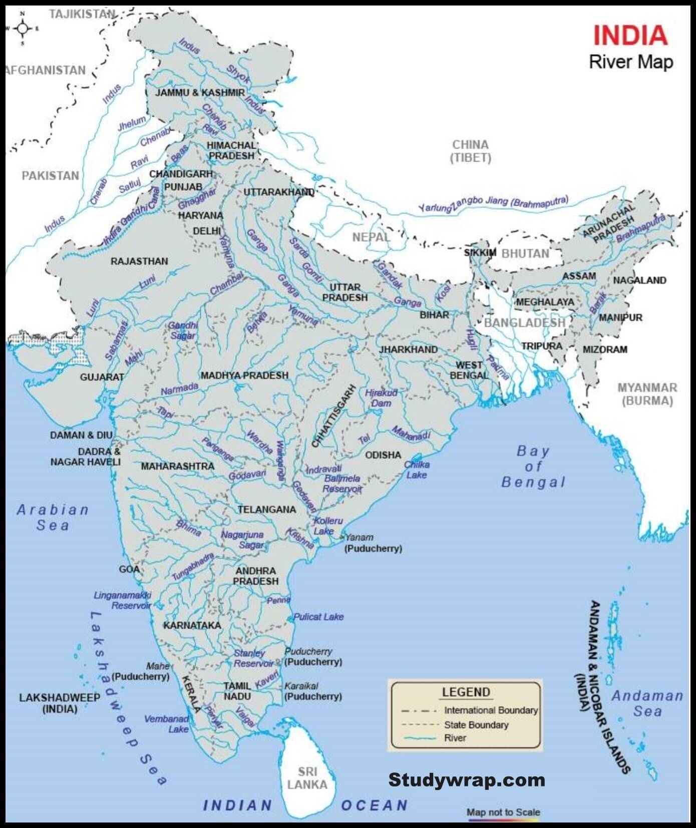
- Indus River System
- Brahmaputra River System
- Ganga River System
- Narmada River System
- Tapti River System
- Godavari River System
- Krishna River System
- Cauvery River System
- Mahanadi River System
-
-
-
-
- The Indian Drainage System is an outcome of-
-
- evolutionary process of three major physiographic unit
- The nature and characteristic of precipitation
-
Classification Drainage System of India
On The Basis Of Size Of Catchment Area
Major river basin
-
-
-
- With more than 20000 sq. km of catchment area.
- It includes 14 drainage basins Ganga, Brahmaputra, Tapi, Narmada, Krishna, Mahi, Sabarmati, etc.
-
-
Medium River Basin
-
-
-
- With catchment area between 200 to 20000 sq. km.
- Eating fruits 44 river basins such as Kalindi, Meghna, and Periyar etc.
-
-
Minor River Basin
-
-
-
- With catchment area of less than 2000 sq. km.
- These includes 55 river Basin.
-
-
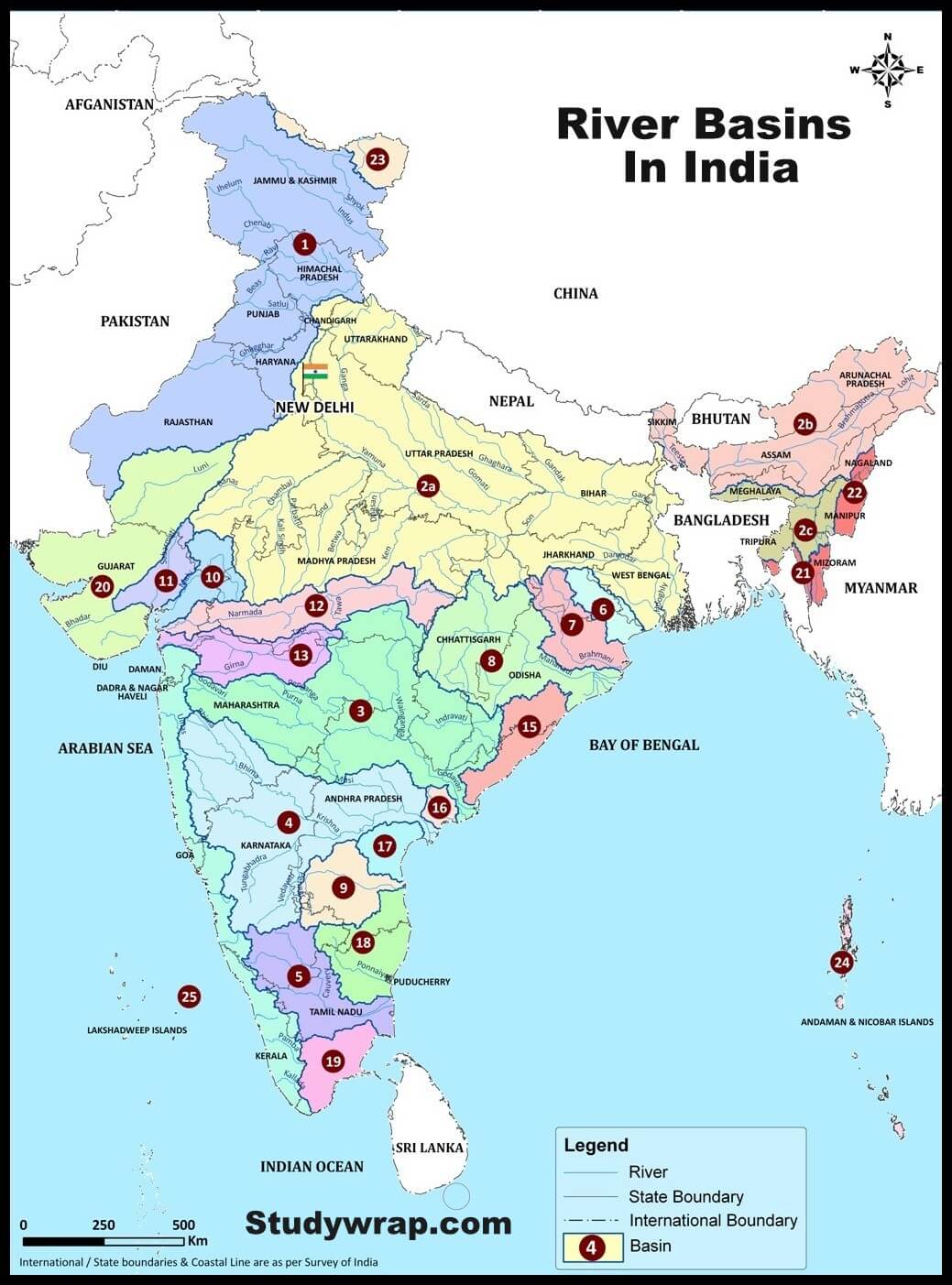
|
Sl. No |
Basin Code |
Basin Name |
Area(sq.km) |
|
1 |
1 |
Indus (Up to border) Basin |
453931.87 |
|
2 |
2a |
Ganga Basin |
808334.44 |
|
3 |
2b |
Brahmaputra Basin |
186421.6 |
|
4 |
2c |
Barak and others Basin |
45622.41 |
|
5 |
3 |
Godavari Basin |
302063.93 |
|
6 |
4 |
Krishna Basin |
254743.31 |
|
7 |
5 |
Cauvery Basin |
85624.44 |
|
8 |
6 |
Subarnarekha Basin |
25792.16 |
|
9 |
7 |
Brahmani and Baitarni Basin |
51893.68 |
|
10 |
8 |
Mahanadi Basin |
139659.15 |
|
11 |
9 |
Pennar Basin |
54243.43 |
|
12 |
10 |
Mahi Basin |
38336.8 |
|
13 |
11 |
Sabarmati Basin |
30678.59 |
|
14 |
12 |
Narmada Basin |
92670.51 |
|
15 |
13 |
Tapi Basin |
63922.91 |
|
16 |
14 |
West flowing rivers South of Tapi Basin |
111643.87 |
|
17 |
15 |
East flowing rivers between Mahanadi and Godavari |
46243.06 |
|
18 |
16 |
East flowing rivers between Godavari and Krishna |
10345.16 |
|
19 |
17 |
East flowing rivers between Krishna and Pennar |
23335.82 |
|
20 |
18 |
East flowing rivers between Pennar and Cauvery |
63646.21 |
|
21 |
19 |
East flowing rivers South of Cauvery Basin |
38646.11 |
|
22 |
20 |
West flowing rivers of Kutch and Saurashtra including |
184441.06 |
|
23 |
21 |
Minor rivers draining into Bangladesh Basin |
5453.23 |
|
24 |
22 |
Minor rivers draining into Myanmar Basin |
24731.08 |
|
25 |
23 |
Area of North Ladakh not draining into Indus |
29238.78 |
Based On Origin Of River
The Himalayan Rivers
-
-
-
- Perennial rivers
- Indus, Ganga, Brahamputra and their tributaries.
-
-
The Peninsular Rivers
-
-
-
- Non perennial rivers.
- Mahanadi, Godavari, Krishna, Kaveri, Narmada, Tapi etc.
- It can be classified into two types –
- East flowing peninsular river system – Eg. Godavari, Krishna, Kaveri, Mahanadi etc.
- West flowing peninsular river system – Narmada, Tapi etc.
-
-
Based On Type Of Drainage
-
-
-
- Himalayan Rivers – these flow to seas.
- Deccan Rivers – these flows to seas.
- Coastal rivers – flows toward sea.
- Inland drainage basin – streams like Sabarmati in western Rajasthan are mainly seasonal in character, draining into the inland basin and salt lakes in Rann of Kuchchh. Only river that flow through salt desert is Luni.
-
-
Based on Orientation to Sea
East Flowing Rivers Or Bay Of Bengal Drainage
-
-
-
- These rivers drains down to Bay of Bengal.
- East flowing rivers
- 77% of the drainage area of the country is oriented towards Bay of Bengal.
- Over 90% of water drains into Bay of Bengal.
- The Ganga, the Brahamputra, Mahanadi, Kaveri, Krishna, Pennuru, Vaigai etc. are example.
-
-
West Flowing Rivers Or Arabian Sea Drainage
-
-
-
- The rivers that drains into Arabian Sea.
- West flowing rivers.
- 23% of the drainage area of the country is oriented towards the Arabian Sea.
- Rest is drained into Arabian Sea + all inlet inland drainage system.
- The Indus, the Narmada, Tapi, Mahi, Sabarmati and the large swift flowing western coast rivers descending from Sahyadri.
-
-
Lop Sided Distribution
-
- The Arabian Sea drainage or western drainage receives less rainfall (Rajasthan, Punjab and Haryana receives very low rainfall)
- The eastern drainage or Bay of Bengal drainage receives rainfall from both from south west and North West monsoon.
- Most of the Himalayan Rivers flow into eastern drainage.
- Indian rivers that flow into Arabian Sea are seasonal and non-perennial.
- Occurrence of more cyclonic rainfall in eastern part is another reason.
Himalayan Drainage System
-
- It consists of river originating in the Himalayas and Trans Himalayan region. It further consists of three river systems namely –
-
- Ganga
- Brahmaputra
- Indus
-
- Since these are fed both by melting of snow and Precipitation Rivers of this system are perennial.
- The various geographical features made by Himalayan rivers are-
-
- In upper reaches – gorges, v shaped valley, rapids, waterfalls, truncated Spurs etc.
- In plain areas for middle part – while entering the plains, they form depositional features like that of valleys, oxbow lakes, floodplains, braided channel, and deltas near mouth of the river. Over the plains did display a strong meandering tendency and shift there courses frequently.
-
- It consists of river originating in the Himalayas and Trans Himalayan region. It further consists of three river systems namely –
Peninsular Drainage System
-
- Peninsular rivers are much older than Himalayan Rivers.
- The peninsular drainage is mainly concordant except for a few rivers in Upper Peninsula region.
- They are non-perennial rivers with maximum discharge in rainy season.
- Peninsular rivers have reached mature stage and have almost reached their base level hence, vertical down cutting is negligible.
- Rivers are characterized by broad and shallow valley.
- River banks shows gentle slope except for limited taxpayer flaunting forms Street sides.
- The main water divide in Peninsular River is by Western Ghats which runs from north to south close to Western coast.
- Velocity of water in peninsular rivers and the load carrying capacity of streams is low due to low gradient.
- Peninsular drainage system can be divided into following parts –
-
- East flowing river like Mahanadi, Godavari, Krishna, Kaveri. These rivers form delta at their mouth.
- West flowing river of Narmada and Tapi which drains into Arabian Sea. These river form estuaries.
-
Inland Drainage
-
- Some rivers of India are not able to reach the sea and constitute inland drainage.
- Large parts of the Rajasthan desert and parts of Aksai Chin in Ladakh have inland drainage.
- The Ghaggar is the most important river of inland drainage. It is a seasonal stream which rises on the lower slopes of the Himalayas and forms boundary between Haryana and Punjab.
- It gets lost in the dry sands of Rajasthan near Hanumangarh after traversing a distance of 465 km.
- Earlier, this river was an affluent of the Indus, the dry bed of the old channel is still traceable.
- Its main tributaries are the Tangri, the Markanda, the Saraswati and the Chaitanya.
- It contains a lot more water in rainy season when its bed becomes 10 km wide at places.
- Most of the streams draining western slopes of the Aravalli Range dry up immediately after they enter the sandy arid areas to the west of this range.
So, this was all about The Drainage System of India or The Indian Drainage System.
In the next post (Click here), we will learn in details about the Indus River System.

Very nice explanation… Excellent notes
Like!! I blog quite often and I genuinely thank you for your information. The article has truly peaked my interest.