
Rivers of India and their Tributaries (Complete List)
River Basin, Their Origin, Mouth and Length
Rivers of India and their Tributaries
(River Basin, Their Origin, Mouth and Length)
Table of Contents
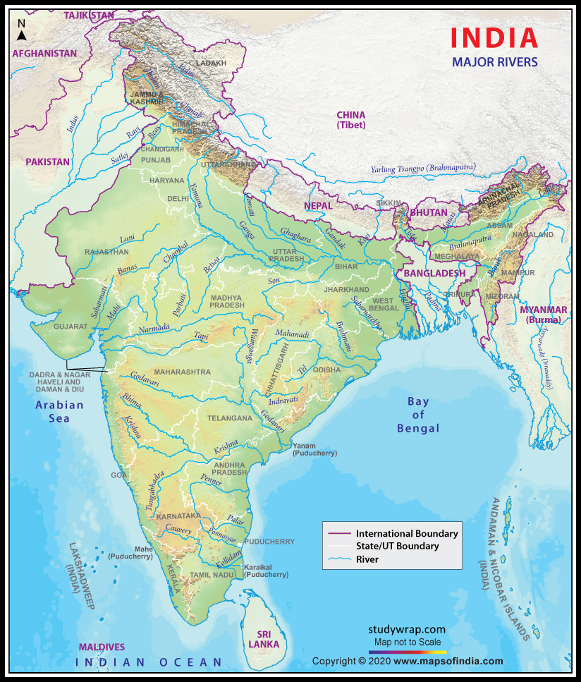
- In this article, we have tried to cover up all the information related to the Rivers of India and their Tributaries.
- India is Land of River. Here many different River flows and gets merge into each other in due course from their origin till their end into the Ocean/sea. So, with this Article we have tried to cover up all the important Rivers of India and their Tributaries.
- Must read this complete article to gain the knowledge of the Rivers of India and their Tributaries, their origin, their Mouth and length. Hope this data will help you to connect with our countries’ rivers. We have a similar post which you will find useful for your preparation of Competitive exam – Indian Cities situated on River Banks.

Rivers of India and their Tributaries of North India
Origin and Mouth of Indus and its Tributaries
|
River |
Origin |
Mouth |
Length |
|
Indus |
Sengge Zangbo and Gar Tsangpo, Tibet Plateau, China |
Indus river delta ( near Karachi, Pakistan mainly and some parts of Gujarat) |
2880 km |
|
Sutlej |
Lake Rakshastal, Tibet, China |
Sutlej joins Chenab near Unch sharif, Pakistan, forming Panjnad river which in turn mixes with Indus river near Bahawalpur of Pakistan |
1500 km |
|
Beas |
Beas Kund, Rohtang Pass, Himachal Pradesh |
Joins Sutlej river near Makhu, Firozpur, Punjab |
470 km |
|
Parbati |
Man Talai Flacier near Pin Parbati Pass |
Mixes with Beas river at Bhuntar, near Kullu of Himachal Pradesh |
|
|
Chenab |
Bara Lacha Pass, Lahaul and Spiti, Himachal Pradesh |
Confluences with Sutlej near Unch Sharif, Pakistan to form Panjnad river which in turn mixes with Indus river |
960 km |
|
Ravi |
Kangra, Himachal Pradesh |
joins Chenab river, Pakistan |
720 km |
|
Jhelum |
Verinag spring, Anantnag, Jammu & Kashmir |
confluence with the Chenab river, Pakistan |
725 km |
|
Suru |
Panzella Glacier, Pensi La pass, Kargil |
Confluence with Indus River at Nurla, Marol, Skardu, Pakistan |
185 km |
|
Dras |
Machoi glacier, Zoji La, near Soanmarg, Jammu and Kashmir |
Suru River at Kharul, Kargil |
86 km |
|
Shyok |
Originates at the Rimo Glacier, Siachen Glacier. |
joins the Indus at Keris, east of the town of Skardu, Pakistan |
550 km |
|
Zanskar |
Doda River (First Branch), Kargyag and Tsarap River |
Joins Indus river near Nimmu in Laddakh |
|
|
Tsarap |
Pankpo La, Sarchu |
Joins doda river to form Zanskar river near Padum, Kargil |
182 km |
|
Doda |
Drang Drang glacier, Pensi La |
Joins doda river to form Zanskar river near Padum, Kargil |
79 km |
Origin and Mouth of Ganges and its Tributaries
|
River |
Origin |
Mouth |
Length |
|
Ganga |
Gangotri, Satopnath and Khatling glacier, Uttarakhand |
Ganges delta, Bay of Bengal situated in India & Bangladesh |
2525 km |
|
Hooghly |
Distributary of Ganga and splits out near Farakka barrage near Murshidabad, West Bengal |
Bay of Bengal |
260 km |
|
Damodar |
Chulha pani, Latehar, Chota Nagpur Plateau, Jharkhand |
Hooghly river, Howrah District, West Bengal |
592 km |
|
Meghana |
Distributary of Brahmaputra |
Bhola district, Bangladesh, Bay of Bengal |
|
|
Padma |
Distributary of Ganga |
Merges with Meghna river near Chandpur district, Bangladesh |
120 km |
|
Mahananda |
Paglajhora falls, Darjeeling, West Bengal |
Merges with Ganga, Godagiri, Nawabganj District, Bangladesh |
360 km |
|
Kosi |
Saptkoshi tributaries (Sun Kosi, Arun, Tamur etc), Tribenighat, Nepal |
Meets Ganga near Kursela, Bihar |
729 km |
|
Kali |
Rajaji Range, Sivalik Hills, Uttar Pradesh |
merges with the Ganga River |
150 km |
|
Ramganga |
Dudhatoli range, Pauri Garhwal, Uttarakhand |
Confluences with the Ganga Near Ibrahimpur, Uttar Pradesh |
596 km |
|
Gandak |
Nhubine Himal glacier, Mustang, Nepal |
confluence with the Ganga, Sonpur, Bihar |
630 km |
|
Son |
Amarkantak, Anuppur district, Madhya Pradesh |
merges with Ganga, near north of Patna, Bihar |
784 km |
|
Ghaghra |
Mapchachungo glacier, Tibet, China |
confluence with the Ganges at Revelganj, Bihar |
1080 km |
|
Gomti |
Gomat tal (formally known as Fulhaar jheel), Pilibhit, Uttar Pradesh |
meets the Ganga near Ghazipur, Uttar Pradesh |
900 km |
|
Sarayu |
Nanda Kot, Sarmul, Bageshwar, Uttarakhand |
flows into the Ganges near the town of Chhapra, Uttar Pradesh |
350 km |
|
Yamuna |
Yamunotri glacier, Banderpooch, Uttarkashi district, Uttarakhand |
merges with the Ganges at Triveni Sangam, Prayagraj, Uttar Pradesh |
1376 km |
|
Ramganga |
Namik glacier, Pauri Garhwal, Uttarakhand |
Ganga, Ibrahimpur, Uttarpradesh |
|
|
Alaknanda |
Confluence of Satopanth Glacier and Bhagirathi Kharak Glacier, Uttarakhand |
Merges with Ganga, at Devprayag, Uttarakhand |
195 km |
|
Bhagirathi |
Gaumukh, Uttarakhand |
Joins Ganga at Devprayag, Uttarakhand |
205 km |
Origin and Mouth of Yamuna and its Tributaries
|
River |
Origin |
Mouth |
Length |
|
Yamuna |
Yamunotri Glacier, Uttarakhand |
Merges with Ganga at Allahabad (Triveni Sangam – Kumbh Mela spot) |
1376 km |
|
Chambal |
Janapav Hills, Vindhya Range, near Mhow, Madhya Pradesh |
Merges with Yamuna at Border of Bhind & Etawah, Uttar Pradesh |
1024 km |
|
Tons |
Ruinsara snout, Bandarpunch, Uttarakhand |
Confluences with Yamuna, below Kalsi near Dehradun, Uttarakhand |
|
|
Ken |
Ahirgawan village, Jabalpur District |
Merges with Yamana at Chilla Village, Fatehpur, Uttar Pradesh |
427 km |
|
Hindon |
Shivalik Range, Saharanpur District |
Joins Yamuna just Outside Delhi |
400 km
|
|
Sindh |
Malwa Plateau, Vidisha district, Madhya Pradesh |
Joins Yamuna near Etawah district, Uttar Pradesh |
470 km |
|
Betwa |
Vindhya Range, Madhya Pradesh |
Confluences with Yamuna in Hamirpur District, Uttar Pradesh |
590 km |
Origin and Mouth of Brahmaputra and its Tributaries
|
River |
Origin |
Mouth |
Length |
|
Brahmaputra |
Angsi glacier, Mansarovar, Tibet, China |
Ganges Delta, Bangladesh (Bay of Bengal) |
2900 km |
|
Dhansiri |
Laisang peak, Nagaland |
Brahmaputra river |
352 km |
|
Dihing |
Patkai Hills, North east Indian border with Burma, Arunachal Pradesh |
Confluence with Brahmaputra at Dihingmukh in Assam |
380 km |
|
Dibang (Sikang) |
Keya pass, India China border, Dibang valley district, Arunachal Pradesh |
Merges with River Lohit, Sadiya, Assam |
195 km |
|
Kameng |
Glacial lake, Tawang, Arunachal Pradesh |
Joins Brahmaputra at Tezpur, Assam |
264 km |
|
Kopili |
Meghalaya plateau |
confluence with the Brahmaputra in Assam |
290 km |
|
Lohit |
Zayal Chu range, east Tibbet |
Meets Brahmaputra at the head of the Brahmaputra valley |
|
|
Manas |
Bhutan |
Merges with Brahmaputra at Jogighopa, Assam |
376 km |
|
Sankosh |
Bhutan |
Brahmaputra, Assam |
|
|
Subansiri |
Himalayas, China |
Joins at Brahmaputra at Lakhimpur, Assam |
442 km |
|
Teesta |
Pauhunri & Zemu glaciers, Cholamu & Gurudongmar lakes, Sikkim |
Confluences with Brahmaputra, near Fulchori, Rangpur, Bangladesh |
315 km |
|
Torsa |
Chumbi valley, Tibet, China |
Brahmaputra, Bangladesh |
358 km |
|
Wang Chhu, or Raidāk |
Himalayas, Bhutan |
confluences with the Brahmaputra in Kurigram District, Bangladesh |
370 km |
Peninsular Indian Rivers Flowing to Bay of Bengal
Origin and Mouth of Godavari and its Tributaries
|
River |
Origin |
Mouth |
Length |
|
Godavari |
Brahmagiri mountains, Triambakeshwar, Nashik, Maharashtra |
Bay of Bengal, near East Godavari district, Andhra Pradesh |
1465 km |
|
Indravati |
Dandkaranya range, Kalahandi district, Odisha |
Merges with Godavari near border of Somnoor Sangam, Sironcha, Gadchiroli, Maharashtra, Chhattisgarh and Telangana |
535 km |
|
Kadva |
rises in the Sahyadris to the north-west of Dindori Taluka, Nashik, Maharashtra |
Meets Godavari in Nashik, Khandesh, Maharashtra |
74 km |
|
Purna |
Ajanta Range, Aurangabad, Maharashtra |
Joins Godavari at Jambulbet, Marathwada, Maharashtra |
373 km |
|
Pranahita |
confluence of Wardha and Wainganga, near Sirpur Kagaznagar, Telengana |
Confluences with Godavari, near Kaleshwaram, Telangana |
113 km |
|
Wardha |
Satpura range, Multai, Betul district of Madhya Pradesh |
joins the Wainganga forming the Pranahita river |
528 km |
|
Wainganga |
Satpura range, Mundara, Seoni district, Madhya Pradesh |
joins the Wardha forming the Pranhita river |
569 km |
|
Mnjira |
Balaghat hills, Ahmednagar district, Maharashtra |
Merges with Godavari, near Kandhakurthi, Karnataka |
724 km |
|
Darna |
Kulang hill, Sahyadris, Nashik, Maharashtra |
Merges with Godavari River, Darnasangvi, Nashik, Khandesh, Maharashtra |
80 km |
|
Painganga |
Ajanta range, Aurangabad, Maharashtra |
Wardha river, Chandrapura district, Maharashtra |
676 km |
|
Kolab |
Sinkaran hiils, Koraput, Odisha |
Meets Godavari at Kunavaram, Andhra Pradesh |
418 km |
Origin and Mouth of Krishna and its Tributaries
|
River |
Origin |
Mouth |
Length |
|
Krishna |
Near Mahabaleshwar, Satara district, Maharashtra |
Bay of Bengal, near Hamsaladeevi, Krishna district, Andhra Pradesh |
1400 km |
|
Tungabhadhra |
Confluence of Tunga and Bhadhra near Koodli, Bhadravathi, Karnataka |
Meets Krishna river, near Alampur, Mahbubnagar, Telangana |
531 km |
|
Bhima |
Bhimashankar, Maharashtra |
Merges in Krishna river, near Raichur, Telengana |
861 km |
|
Dudhaganga |
Western Ghats, Sindhudurg district, Maharashtra |
Joins Krishna |
|
|
Mula-Mutha |
confluence of Mula and Mutha rivers near Pune |
meets Bhima river in PuneMaharashtra |
|
|
Malaprabha |
Western ghats, near Belgaum, Karnataka |
Krishna river, near Kudalasangama, Bagalkot, Karnataka |
304 km |
|
Ghataprabha |
Western ghats, Sindhudurg, Maharashtra |
Joins Krishna river at Chikksangam, Almatti |
283 km |
|
Venna |
VennamLake, Mahabaleshwar, Maharashtra |
Confluences with Krishna river, Satara, Maharashtra |
130 km |
|
Koyna |
Mahabaleshwar, Satara district,Maharashtra |
Meets Krishna river, near Karad, Satara |
130 km |
Origin and Mouth of Kaveri (Cavery) and its Tributaries
|
River |
Origin |
Mouth |
Length |
|
Kaveri |
Talakaveri, Kodagu district, Karnataka |
Kaveri delta, Bay of Bengal near Poompuhar, Tamil Nadu |
805 km |
|
Amaravati |
Anamalai hills, Pambar, Chinnar rivers |
Kaveri river at Karur, Tamil Nadu |
282 km |
|
Arkavati |
Nandi Hills of Chikkaballapura district, Karnataka |
joins Kaveri river near Mekedatu |
|
|
Bhavani |
Nilgiri Hills, Silent valley National Park, Kerala |
Joins Kaveri river at Kongu Nadu region of Tamil Nadu |
215 km |
|
Hemavati |
Western ghats, Chikmagalur, Karnataka |
JoinsKaveri river near Krishnarajasagara, Karnataka |
245 km |
|
Kabini |
Forms on the confluence of the Panamaram River and the Mananthavady River near Wayanad District, Kerala |
join the Kaveri River at Tirumakudalu Narasipura, Mysore, Karnataka. |
|
|
Noyyal |
Vellingiri Hills, Western Ghats, Tamil Nadu |
Joins Kaveri river |
180km |
|
Shimsha |
Tiptur taluk, Tumkur district, Karnataka |
Meets Kaveri near Chamrajanagar District, Karnataka |
221 km |
Other Most Important East Flowing Rivers
|
River |
Origin |
Mouth |
Length |
|
Mahanadi |
Dhamtari, Dandkaranya, Chhattisgarh |
Bay of Bengal, near Paradeep at False Point, Kendrapada, Odisha |
900 km |
|
Vellar |
Shevaroy Hills, near Salem, Tamil Nadu |
Bay of Bengal, near Parangipettai, Tamil Nadu |
150 km |
|
Ponnaiyar |
Nandi Hills, Nandidurg, Chikkaballapur, Karnataka |
Bay of Bengal near Cuddalore, Tamil Nadu |
500 km |
|
Palar |
Nandi Hills, Kolar district, Karnataka |
Bay of Bengal, near Vayalur, Tamil Nadu |
348 km |
|
Vaigai |
Varusanadu Hills, Tamil Nadu |
Palk Strait, Tamil Nadu |
258 km |
|
Penner (Penna) |
Nandi Hills, Chikkaballapur district, Karnataka |
Bay of Bengal, near Nellore, Andhra Pradesh |
597 km |
|
Subarnarekha |
Chota Nagpur plateau, near Ranchi, Jharkhand |
Kirtania Port, near Talsari, Bay of Bengal |
395 km |
Peninsular Indian Rivers Flowing to Arabian Sea
Origin and Mouth of Tapti (or Tapi) and its Tributaries
|
River |
Origin |
Mouth |
Length |
|
Tapti (or Tapi) |
Satpura Range, Multai, near Betul, Madhya Pradesh |
Gulf of Khambhat, Arabian sea, near Surat, Gujarat |
724 km |
|
Gomai |
Satpura Range |
Tapti river near Prakasha, Nandurbar, Maharashtra |
|
|
Girna |
Kem Peak in the Western Ghats, Maharashtra |
Confluences with Tapti River |
|
|
Panzara |
near Pimpalner, Dhule, Maharashtra |
Merges with Tapti river |
|
|
Purna |
Satpura Range, Baitul, Madhya Pradesh |
Joins Tapti river, near Changdev, Jalgaon, Maharashtra |
334 km |
Origin and Mouth of Narmada and its Tributaries
|
River |
Origin |
Mouth |
Length |
|
Narmada |
Narmada Kund, Amarkantak Hills, shahdol, Madhya Pradesh |
Gulf of Khambhat, Surat, Gujarat |
1315 km |
|
Kolar |
Vindhya Range, near Sehore district, Madhya Pradesh |
Merges with Narmada, near Raisen district of Madhya Pradesh |
101 km |
|
Shakkar |
Confluence with Narmada near Gadarwara |
||
|
Tawa |
Satpura Range, Betul, Madhya Pradesh |
Joins Narmada near Hoshangabad district |
172 km |
Other Important West Flowing Rivers
|
River |
Origin |
Mouth |
Length |
|
Mahi |
Vindhya Range, Madhya Pradesh |
Gulf of Khambhat, near Bharuch district |
580 km |
|
Sabarmati |
Dhebar lake, Aravali range, near Udaipur, Rajasthan |
Gulf of Khambhat, Gujarat |
371 km |
|
Hiran |
near the Sasa hills in Gir forest, Gujarat |
Arabian Sea, India |
40 km |
|
Chaliyar |
Elambaleri Hills, Western Ghats, Wayanad, Kerala |
Lakshdweep |
169 km |
|
Ulhas |
near Rajmachi hills, Sahyadri range |
Vasai creek, Mumbai |
122 km |
|
Mithi |
Vihar lake and Powai lake, Aarey Colony, Goregaon, Maharashtra |
Arabian sea, Mahim creek, Mumbai |
18 km |
|
Mandovi |
Western Ghats, Bhimgad, Belagavi District, Karnataka |
Arabian sea |
81 km |
|
Zuari |
Hemad-Barshem in western ghats |
Arabian sea |
34 km |
|
Kali |
Kushavali, Karnataka |
Arabian sea |
184 km |
|
Netravati |
Kudremukh, Chikamangaluru, Karnataka |
Arabian sea, near Mangalore, Karnataka |
106 km |
|
Sharavati |
Western Ghats, Tirthahalli, Shimoga, Karnataka |
Arabian sea, near Honnavar, Uttar Kannada district, Karnataka |
128 km |
|
Periyar |
Sivagiri hills, Sundaramala, Tamil Nadu |
Arabian Sea, Vembanad Lake, Kerala |
244 km |
|
Bharathapuzha |
Anamalai Hills, Tamil Nadu |
Lakshdweep sea, Ponnani, Kerala |
209 km |
|
Pamba |
Pulachimalai Hills, Western Ghats, Kerala |
Vembanad Lake, Kerala |
176 km |
Rivers Flowing into the Inner Part of India
|
River |
Origin |
Mouth |
Length |
|
Luni |
Pushkar valley of the Aravalli Range, near Ajmer |
ends in the marshy lands of Rann of Kutch in Gujarat |
495 km |
|
Bhavani |
Nilgiri hills, Western Ghats, Kerala |
217 km |
|
|
Ghaggar |
Shivalik Hills, Himachal Pradesh |
flows only during the monsoon season |
So, this was all about the Rivers of India and their Tributaries with their Origin, Mouth and Length. Hope you have duly liked the Article. Please share your reviews and feedback with us in the comments’ box below.
For more information regarding Rivers of India and their Tributaries, You can refer following Great Articles –
Indian Drainage System/Indian River System
Ganga Brahmaputra River System

Nice Article… Need Such more
Well written